You are here: Home > Network List > XT97 - Colorado BB Array - Lodore Stations List
> Station ZENO XT.ZENO > Earthquake Result Viewer
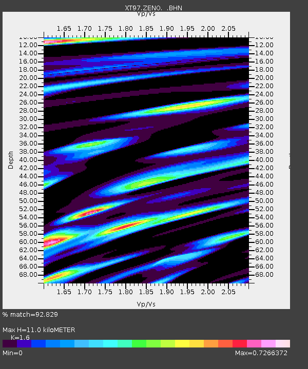
ZENO XT.ZENO - Earthquake Result Viewer
| Earthquake location: |
Northern Peru |
| Earthquake latitude/longitude: |
-4.4/-76.7 |
| Earthquake time(UTC): |
1997/10/28 (301) 06:15:17 GMT |
| Earthquake Depth: |
112 km |
| Earthquake Magnitude: |
6.6 MB, 6.3 MS, 7.2 UNKNOWN, 6.6 ME |
| Earthquake Catalog/Contributor: |
WHDF/NEIC |
|
| Network: |
XT Colorado BB Array - Lodore |
| Station: |
ZENO XT.ZENO |
| Lat/Lon: |
40.60 N/108.82 W |
| Elevation: |
2302 m |
|
| Distance: |
53.6 deg |
| Az: |
329.771 deg |
| Baz: |
138.75 deg |
| Ray Param: |
0.06564791 |
| Estimated Moho Depth: |
11.0 km |
| Estimated Crust Vp/Vs: |
1.60 |
| Assumed Crust Vp: |
6.207 km/s |
| Estimated Crust Vs: |
3.879 km/s |
| Estimated Crust Poisson's Ratio: |
0.18 |
|
| Radial Match: |
92.829 % |
| Radial Bump: |
400 |
| Transverse Match: |
86.84971 % |
| Transverse Bump: |
400 |
| SOD ConfigId: |
6273 |
| Insert Time: |
2010-03-09 01:51:06.220 +0000 |
| GWidth: |
2.5 |
| Max Bumps: |
400 |
| Tol: |
0.001 |
|

Signal To Noise
| Channel | StoN | STA | LTA |
| XT:ZENO: :BHN:19971028T06:23:56.125012Z | 8.150686 | 8.489354E-7 | 1.04155085E-7 |
| XT:ZENO: :BHE:19971028T06:23:56.125012Z | 13.566684 | 1.4552929E-6 | 1.07269614E-7 |
| XT:ZENO: :BHZ:19971028T06:23:56.125012Z | 18.443857 | 3.4997383E-6 | 1.8975088E-7 |
| Arrivals |
| Ps | 1.1 SECOND |
| PpPs | 4.4 SECOND |
| PsPs/PpSs | 5.5 SECOND |


