You are here: Home > Network List > CI - Caltech Regional Seismic Network Stations List
> Station MPM Manuel Prospect Mine, California, USA > Earthquake Result Viewer
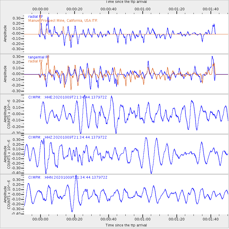
MPM Manuel Prospect Mine, California, USA - Earthquake Result Viewer
*The percent match for this event was below the threshold and hence no stack was calculated.
| Earthquake location: |
Vanuatu Islands |
| Earthquake latitude/longitude: |
-17.2/167.4 |
| Earthquake time(UTC): |
2020/10/09 (283) 21:22:23 GMT |
| Earthquake Depth: |
10 km |
| Earthquake Magnitude: |
5.2 Mww |
| Earthquake Catalog/Contributor: |
NEIC PDE/us |
|
| Network: |
CI Caltech Regional Seismic Network |
| Station: |
MPM Manuel Prospect Mine, California, USA |
| Lat/Lon: |
36.06 N/117.49 W |
| Elevation: |
185 m |
|
| Distance: |
88.4 deg |
| Az: |
51.563 deg |
| Baz: |
247.523 deg |
| Ray Param: |
$rayparam |
*The percent match for this event was below the threshold and hence was not used in the summary stack. |
|
| Radial Match: |
62.176857 % |
| Radial Bump: |
400 |
| Transverse Match: |
34.10677 % |
| Transverse Bump: |
400 |
| SOD ConfigId: |
22732711 |
| Insert Time: |
2020-10-23 21:28:03.550 +0000 |
| GWidth: |
2.5 |
| Max Bumps: |
400 |
| Tol: |
0.001 |
|
Signal To Noise
| Channel | StoN | STA | LTA |
| CI:MPM: :HHZ:20201009T21:34:44.137972Z | 2.4141595 | 2.4664902E-7 | 1.0216766E-7 |
| CI:MPM: :HHN:20201009T21:34:44.137972Z | 0.6001212 | 9.175259E-8 | 1.528901E-7 |
| CI:MPM: :HHE:20201009T21:34:44.137972Z | 1.033486 | 1.1159643E-7 | 1.0798059E-7 |
| Arrivals |
| Ps | |
| PpPs | |
| PsPs/PpSs | |


