You are here: Home > Network List > TA - USArray Transportable Network (new EarthScope stations) Stations List
> Station L15K Ungalak Mountain, AK, USA > Earthquake Result Viewer
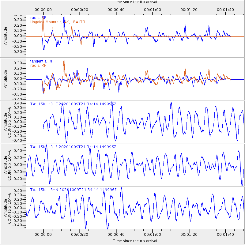
L15K Ungalak Mountain, AK, USA - Earthquake Result Viewer
*The percent match for this event was below the threshold and hence no stack was calculated.
| Earthquake location: |
Vanuatu Islands |
| Earthquake latitude/longitude: |
-17.2/167.4 |
| Earthquake time(UTC): |
2020/10/09 (283) 21:22:23 GMT |
| Earthquake Depth: |
10 km |
| Earthquake Magnitude: |
5.2 Mww |
| Earthquake Catalog/Contributor: |
NEIC PDE/us |
|
| Network: |
TA USArray Transportable Network (new EarthScope stations) |
| Station: |
L15K Ungalak Mountain, AK, USA |
| Lat/Lon: |
61.68 N/161.49 W |
| Elevation: |
219 m |
|
| Distance: |
82.4 deg |
| Az: |
14.385 deg |
| Baz: |
209.866 deg |
| Ray Param: |
$rayparam |
*The percent match for this event was below the threshold and hence was not used in the summary stack. |
|
| Radial Match: |
49.177914 % |
| Radial Bump: |
400 |
| Transverse Match: |
49.40145 % |
| Transverse Bump: |
380 |
| SOD ConfigId: |
22732711 |
| Insert Time: |
2020-10-23 21:32:50.184 +0000 |
| GWidth: |
2.5 |
| Max Bumps: |
400 |
| Tol: |
0.001 |
|
Signal To Noise
| Channel | StoN | STA | LTA |
| TA:L15K: :BHZ:20201009T21:34:14.149996Z | 1.6950555 | 3.2974125E-7 | 1.9453124E-7 |
| TA:L15K: :BHN:20201009T21:34:14.149996Z | 0.60454524 | 8.610547E-8 | 1.4243015E-7 |
| TA:L15K: :BHE:20201009T21:34:14.149996Z | 0.4299573 | 7.9187195E-8 | 1.8417455E-7 |
| Arrivals |
| Ps | |
| PpPs | |
| PsPs/PpSs | |


