You are here: Home > Network List > EC - Ecuador Seismic Network Stations List
> Station ANTS OVANTI_S > Earthquake Result Viewer
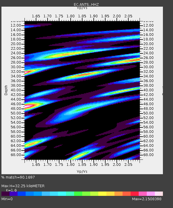
ANTS OVANTI_S - Earthquake Result Viewer
| Earthquake location: |
Easter Island Region |
| Earthquake latitude/longitude: |
-28.6/-112.3 |
| Earthquake time(UTC): |
2020/10/10 (284) 13:14:57 GMT |
| Earthquake Depth: |
10 km |
| Earthquake Magnitude: |
6.0 mww |
| Earthquake Catalog/Contributor: |
NEIC PDE/us |
|
| Network: |
EC Ecuador Seismic Network |
| Station: |
ANTS OVANTI_S |
| Lat/Lon: |
0.50 S/78.17 W |
| Elevation: |
4580 m |
|
| Distance: |
43.0 deg |
| Az: |
55.363 deg |
| Baz: |
226.318 deg |
| Ray Param: |
0.07286132 |
| Estimated Moho Depth: |
32.25 km |
| Estimated Crust Vp/Vs: |
1.60 |
| Assumed Crust Vp: |
6.472 km/s |
| Estimated Crust Vs: |
4.045 km/s |
| Estimated Crust Poisson's Ratio: |
0.18 |
|
| Radial Match: |
90.1697 % |
| Radial Bump: |
400 |
| Transverse Match: |
78.92006 % |
| Transverse Bump: |
400 |
| SOD ConfigId: |
22732711 |
| Insert Time: |
2020-10-24 13:23:01.975 +0000 |
| GWidth: |
2.5 |
| Max Bumps: |
400 |
| Tol: |
0.001 |
|

Signal To Noise
| Channel | StoN | STA | LTA |
| EC:ANTS: :HHZ:20201010T13:22:25.867993Z | 3.84699 | 4.2349905E-7 | 1.1008581E-7 |
| EC:ANTS: :HHN:20201010T13:22:25.867993Z | 1.2431858 | 1.3966716E-7 | 1.1234618E-7 |
| EC:ANTS: :HHE:20201010T13:22:25.867993Z | 1.8329245 | 1.8641286E-7 | 1.01702426E-7 |
| Arrivals |
| Ps | 3.2 SECOND |
| PpPs | 12 SECOND |
| PsPs/PpSs | 15 SECOND |


