You are here: Home > Network List > AV - Alaska Volcano Observatory Stations List
> Station PLBL Mt. Peulik Volcano, Alaska > Earthquake Result Viewer
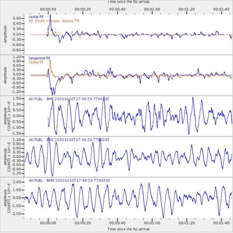
PLBL Mt. Peulik Volcano, Alaska - Earthquake Result Viewer
*The percent match for this event was below the threshold and hence no stack was calculated.
| Earthquake location: |
Myanmar-India Border Region |
| Earthquake latitude/longitude: |
24.6/93.5 |
| Earthquake time(UTC): |
2020/10/10 (284) 17:38:00 GMT |
| Earthquake Depth: |
55 km |
| Earthquake Magnitude: |
5.4 Mww |
| Earthquake Catalog/Contributor: |
NEIC PDE/us |
|
| Network: |
AV Alaska Volcano Observatory |
| Station: |
PLBL Mt. Peulik Volcano, Alaska |
| Lat/Lon: |
57.70 N/156.82 W |
| Elevation: |
461 m |
|
| Distance: |
79.3 deg |
| Az: |
30.957 deg |
| Baz: |
299.325 deg |
| Ray Param: |
$rayparam |
*The percent match for this event was below the threshold and hence was not used in the summary stack. |
|
| Radial Match: |
69.43255 % |
| Radial Bump: |
372 |
| Transverse Match: |
65.204315 % |
| Transverse Bump: |
400 |
| SOD ConfigId: |
22732711 |
| Insert Time: |
2020-10-24 17:41:39.918 +0000 |
| GWidth: |
2.5 |
| Max Bumps: |
400 |
| Tol: |
0.001 |
|
Signal To Noise
| Channel | StoN | STA | LTA |
| AV:PLBL: :BHZ:20201010T17:49:29.779029Z | 2.4439962 | 9.258785E-7 | 3.7883797E-7 |
| AV:PLBL: :BHN:20201010T17:49:29.779029Z | 1.6121792 | 7.332103E-7 | 4.5479456E-7 |
| AV:PLBL: :BHE:20201010T17:49:29.779029Z | 1.2061425 | 9.4275117E-7 | 7.81625E-7 |
| Arrivals |
| Ps | |
| PpPs | |
| PsPs/PpSs | |


