You are here: Home > Network List > TA - USArray Transportable Network (new EarthScope stations) Stations List
> Station E20K Nigu River, AK, USA > Earthquake Result Viewer
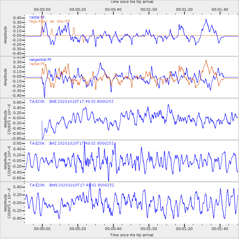
E20K Nigu River, AK, USA - Earthquake Result Viewer
*The percent match for this event was below the threshold and hence no stack was calculated.
| Earthquake location: |
Myanmar-India Border Region |
| Earthquake latitude/longitude: |
24.6/93.5 |
| Earthquake time(UTC): |
2020/10/10 (284) 17:38:00 GMT |
| Earthquake Depth: |
55 km |
| Earthquake Magnitude: |
5.4 Mww |
| Earthquake Catalog/Contributor: |
NEIC PDE/us |
|
| Network: |
TA USArray Transportable Network (new EarthScope stations) |
| Station: |
E20K Nigu River, AK, USA |
| Lat/Lon: |
68.26 N/156.19 W |
| Elevation: |
866 m |
|
| Distance: |
74.5 deg |
| Az: |
21.255 deg |
| Baz: |
297.69 deg |
| Ray Param: |
$rayparam |
*The percent match for this event was below the threshold and hence was not used in the summary stack. |
|
| Radial Match: |
38.61596 % |
| Radial Bump: |
400 |
| Transverse Match: |
37.61879 % |
| Transverse Bump: |
400 |
| SOD ConfigId: |
22732711 |
| Insert Time: |
2020-10-24 17:46:12.043 +0000 |
| GWidth: |
2.5 |
| Max Bumps: |
400 |
| Tol: |
0.001 |
|
Signal To Noise
| Channel | StoN | STA | LTA |
| TA:E20K: :BHZ:20201010T17:49:02.800025Z | 0.5963846 | 7.819591E-8 | 1.3111658E-7 |
| TA:E20K: :BHN:20201010T17:49:02.800025Z | 1.196802 | 1.4406017E-7 | 1.2037091E-7 |
| TA:E20K: :BHE:20201010T17:49:02.800025Z | 0.3281365 | 9.0688765E-8 | 2.7637512E-7 |
| Arrivals |
| Ps | |
| PpPs | |
| PsPs/PpSs | |


