You are here: Home > Network List > TA - USArray Transportable Network (new EarthScope stations) Stations List
> Station I17K Unalakleet, AK, USA > Earthquake Result Viewer
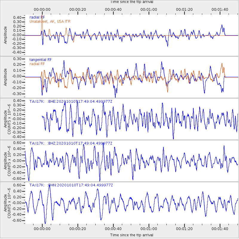
I17K Unalakleet, AK, USA - Earthquake Result Viewer
*The percent match for this event was below the threshold and hence no stack was calculated.
| Earthquake location: |
Myanmar-India Border Region |
| Earthquake latitude/longitude: |
24.6/93.5 |
| Earthquake time(UTC): |
2020/10/10 (284) 17:38:00 GMT |
| Earthquake Depth: |
55 km |
| Earthquake Magnitude: |
5.4 Mww |
| Earthquake Catalog/Contributor: |
NEIC PDE/us |
|
| Network: |
TA USArray Transportable Network (new EarthScope stations) |
| Station: |
I17K Unalakleet, AK, USA |
| Lat/Lon: |
63.89 N/160.70 W |
| Elevation: |
105 m |
|
| Distance: |
74.8 deg |
| Az: |
26.178 deg |
| Baz: |
294.874 deg |
| Ray Param: |
$rayparam |
*The percent match for this event was below the threshold and hence was not used in the summary stack. |
|
| Radial Match: |
53.249622 % |
| Radial Bump: |
400 |
| Transverse Match: |
52.420498 % |
| Transverse Bump: |
400 |
| SOD ConfigId: |
22732711 |
| Insert Time: |
2020-10-24 17:46:23.779 +0000 |
| GWidth: |
2.5 |
| Max Bumps: |
400 |
| Tol: |
0.001 |
|
Signal To Noise
| Channel | StoN | STA | LTA |
| TA:I17K: :BHZ:20201010T17:49:04.499977Z | 0.60150766 | 1.3736391E-7 | 2.2836602E-7 |
| TA:I17K: :BHN:20201010T17:49:04.499977Z | 2.2612932 | 3.9749239E-7 | 1.75781E-7 |
| TA:I17K: :BHE:20201010T17:49:04.499977Z | 1.0898404 | 1.9513868E-7 | 1.7905253E-7 |
| Arrivals |
| Ps | |
| PpPs | |
| PsPs/PpSs | |


