You are here: Home > Network List > OH - Ohio Seismic Network Stations List
> Station MWLO Mercer Wildlife Area Ohio > Earthquake Result Viewer
MWLO Mercer Wildlife Area Ohio - Earthquake Result Viewer
| Earthquake location: |
Easter Island Region |
| Earthquake latitude/longitude: |
-28.6/-112.2 |
| Earthquake time(UTC): |
2020/10/11 (285) 14:41:20 GMT |
| Earthquake Depth: |
10 km |
| Earthquake Magnitude: |
5.7 Mww |
| Earthquake Catalog/Contributor: |
NEIC PDE/us |
|
| Network: |
OH Ohio Seismic Network |
| Station: |
MWLO Mercer Wildlife Area Ohio |
| Lat/Lon: |
40.50 N/84.57 W |
| Elevation: |
266 m |
|
| Distance: |
73.4 deg |
| Az: |
21.63 deg |
| Baz: |
205.158 deg |
| Ray Param: |
0.053054348 |
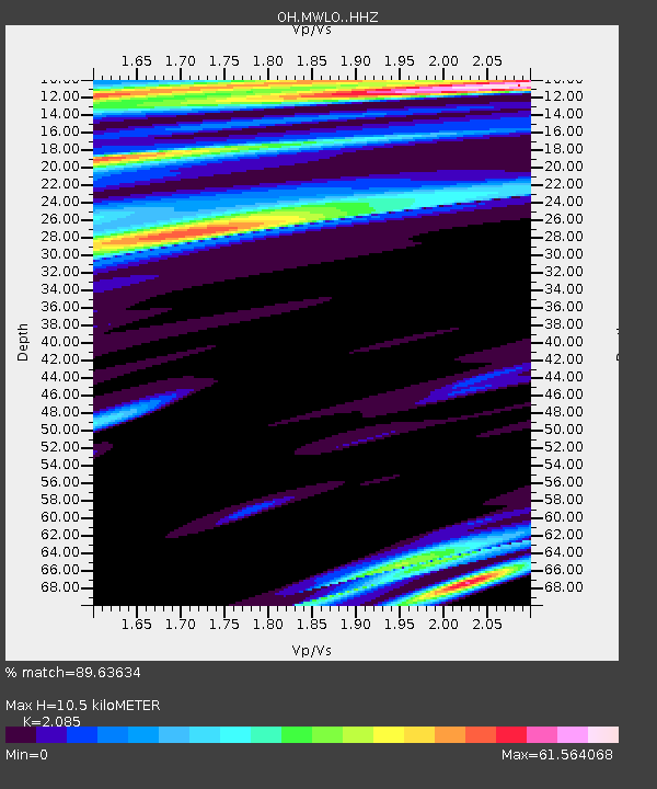
| Estimated Moho Depth: |
10.5 km |
| Estimated Crust Vp/Vs: |
2.09 |
| Assumed Crust Vp: |
6.498 km/s |
| Estimated Crust Vs: |
3.116 km/s |
| Estimated Crust Poisson's Ratio: |
0.35 |
|
| Radial Match: |
89.63634 % |
| Radial Bump: |
294 |
| Transverse Match: |
37.6457 % |
| Transverse Bump: |
383 |
| SOD ConfigId: |
22732711 |
| Insert Time: |
2020-10-25 14:54:12.604 +0000 |
| GWidth: |
2.5 |
| Max Bumps: |
400 |
| Tol: |
0.001 |
|

Signal To Noise
| Channel | StoN | STA | LTA |
| OH:MWLO: :HHZ:20201011T14:52:21.159972Z | 1.712081 | 2.1029477E-6 | 1.2282993E-6 |
| OH:MWLO: :HHN:20201011T14:52:21.159972Z | 1.453994 | 9.98935E-5 | 6.870282E-5 |
| OH:MWLO: :HHE:20201011T14:52:21.159972Z | 1.9132082 | 6.777059E-5 | 3.5422487E-5 |
| Arrivals |
| Ps | 1.8 SECOND |
| PpPs | 4.8 SECOND |
| PsPs/PpSs | 6.6 SECOND |


