You are here: Home > Network List > US - United States National Seismic Network Stations List
> Station AMTX Amarillo, Texas, USA > Earthquake Result Viewer
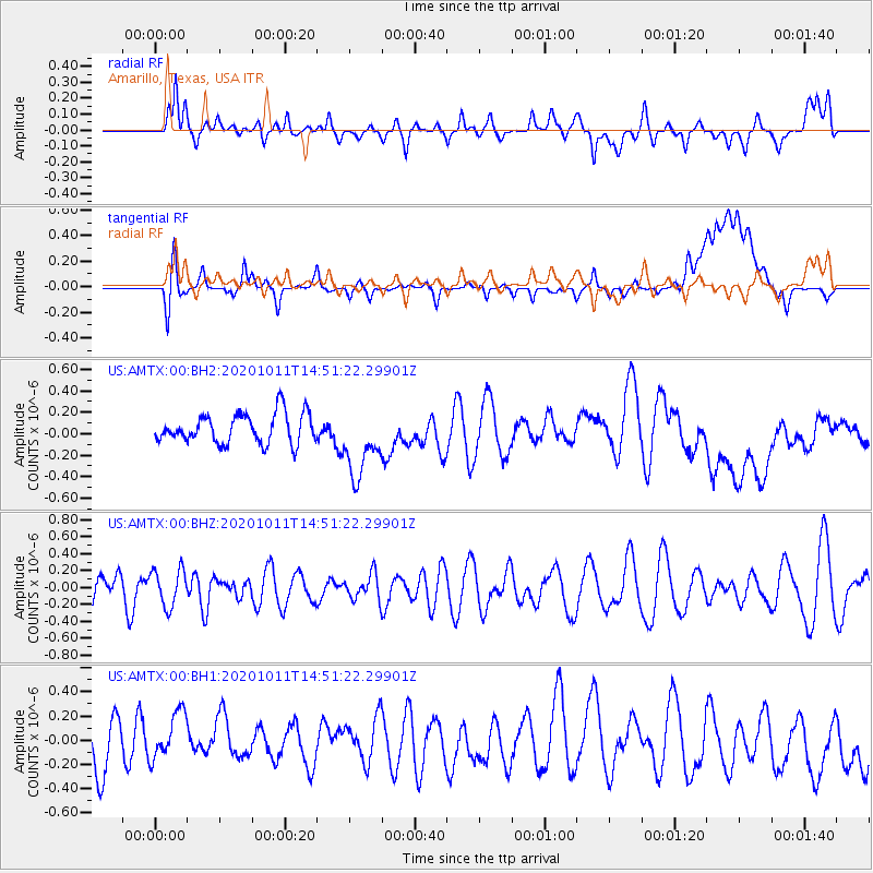
AMTX Amarillo, Texas, USA - Earthquake Result Viewer
*The percent match for this event was below the threshold and hence no stack was calculated.
| Earthquake location: |
Easter Island Region |
| Earthquake latitude/longitude: |
-28.6/-112.2 |
| Earthquake time(UTC): |
2020/10/11 (285) 14:41:20 GMT |
| Earthquake Depth: |
10 km |
| Earthquake Magnitude: |
5.7 Mww |
| Earthquake Catalog/Contributor: |
NEIC PDE/us |
|
| Network: |
US United States National Seismic Network |
| Station: |
AMTX Amarillo, Texas, USA |
| Lat/Lon: |
34.53 N/101.41 W |
| Elevation: |
1010 m |
|
| Distance: |
63.6 deg |
| Az: |
9.903 deg |
| Baz: |
190.555 deg |
| Ray Param: |
$rayparam |
*The percent match for this event was below the threshold and hence was not used in the summary stack. |
|
| Radial Match: |
39.88903 % |
| Radial Bump: |
400 |
| Transverse Match: |
29.13392 % |
| Transverse Bump: |
400 |
| SOD ConfigId: |
22732711 |
| Insert Time: |
2020-10-25 14:58:09.310 +0000 |
| GWidth: |
2.5 |
| Max Bumps: |
400 |
| Tol: |
0.001 |
|
Signal To Noise
| Channel | StoN | STA | LTA |
| US:AMTX:00:BHZ:20201011T14:51:22.29901Z | 1.1649063 | 2.1768786E-7 | 1.8687157E-7 |
| US:AMTX:00:BH1:20201011T14:51:22.29901Z | 1.0145116 | 2.061331E-7 | 2.0318456E-7 |
| US:AMTX:00:BH2:20201011T14:51:22.29901Z | 2.3596678 | 3.198078E-7 | 1.3553087E-7 |
| Arrivals |
| Ps | |
| PpPs | |
| PsPs/PpSs | |


