You are here: Home > Network List > XT01 - Seismic Array in Fiji and Tonga Stations List
> Station VATI Vati > Earthquake Result Viewer
VATI Vati - Earthquake Result Viewer
| Earthquake location: |
Sunda Strait, Indonesia |
| Earthquake latitude/longitude: |
-7.0/104.2 |
| Earthquake time(UTC): |
2002/06/27 (178) 05:50:35 GMT |
| Earthquake Depth: |
11 km |
| Earthquake Magnitude: |
6.0 MB, 6.9 MS, 6.6 MW, 6.5 MW |
| Earthquake Catalog/Contributor: |
WHDF/NEIC |
|
| Network: |
XT Seismic Array in Fiji and Tonga |
| Station: |
VATI Vati |
| Lat/Lon: |
17.44 S/177.76 E |
| Elevation: |
66 m |
|
| Distance: |
72.3 deg |
| Az: |
106.037 deg |
| Baz: |
268.113 deg |
| Ray Param: |
0.053738788 |
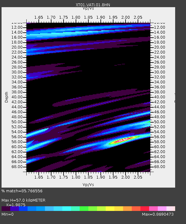
| Estimated Moho Depth: |
57.0 km |
| Estimated Crust Vp/Vs: |
1.99 |
| Assumed Crust Vp: |
5.195 km/s |
| Estimated Crust Vs: |
2.614 km/s |
| Estimated Crust Poisson's Ratio: |
0.33 |
|
| Radial Match: |
85.766556 % |
| Radial Bump: |
400 |
| Transverse Match: |
67.62481 % |
| Transverse Bump: |
400 |
| SOD ConfigId: |
16820 |
| Insert Time: |
2010-03-09 01:52:26.997 +0000 |
| GWidth: |
2.5 |
| Max Bumps: |
400 |
| Tol: |
0.001 |
|

Signal To Noise
| Channel | StoN | STA | LTA |
| XT:VATI:01:BHN:20020627T06:01:29.39302Z | 1.057851 | 5.9682077E-7 | 5.6418224E-7 |
| XT:VATI:01:BHE:20020627T06:01:29.39302Z | 0.74112684 | 3.9046563E-7 | 5.26854E-7 |
| XT:VATI:01:BHZ:20020627T06:01:29.39302Z | 0.782181 | 3.1789747E-7 | 4.0642442E-7 |
| Arrivals |
| Ps | 11 SECOND |
| PpPs | 32 SECOND |
| PsPs/PpSs | 43 SECOND |


