You are here: Home > Network List > WY - Yellowstone Wyoming Seismic Network Stations List
> Station YHH Holmes Hill, YNP, WY, USA > Earthquake Result Viewer
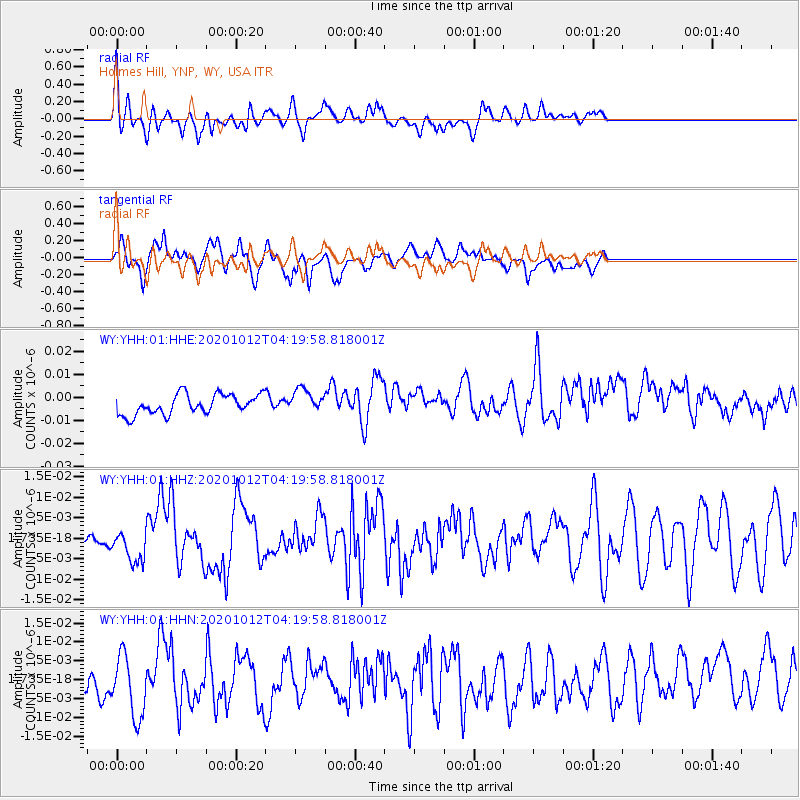
YHH Holmes Hill, YNP, WY, USA - Earthquake Result Viewer
*The percent match for this event was below the threshold and hence no stack was calculated.
| Earthquake location: |
Near Coast Of Chiapas, Mexico |
| Earthquake latitude/longitude: |
14.9/-93.6 |
| Earthquake time(UTC): |
2020/10/12 (286) 04:13:53 GMT |
| Earthquake Depth: |
18 km |
| Earthquake Magnitude: |
5.5 Mww |
| Earthquake Catalog/Contributor: |
NEIC PDE/us |
|
| Network: |
WY Yellowstone Wyoming Seismic Network |
| Station: |
YHH Holmes Hill, YNP, WY, USA |
| Lat/Lon: |
44.79 N/110.85 W |
| Elevation: |
2717 m |
|
| Distance: |
33.2 deg |
| Az: |
337.32 deg |
| Baz: |
148.425 deg |
| Ray Param: |
$rayparam |
*The percent match for this event was below the threshold and hence was not used in the summary stack. |
|
| Radial Match: |
52.716652 % |
| Radial Bump: |
400 |
| Transverse Match: |
56.257114 % |
| Transverse Bump: |
400 |
| SOD ConfigId: |
22732711 |
| Insert Time: |
2020-10-26 04:42:45.368 +0000 |
| GWidth: |
2.5 |
| Max Bumps: |
400 |
| Tol: |
0.001 |
|
Signal To Noise
| Channel | StoN | STA | LTA |
| WY:YHH:01:HHZ:20201012T04:19:58.818001Z | 1.9904892 | 3.988911E-9 | 2.0039852E-9 |
| WY:YHH:01:HHN:20201012T04:19:58.818001Z | 2.0050547 | 8.960904E-9 | 4.469157E-9 |
| WY:YHH:01:HHE:20201012T04:19:58.818001Z | 1.1875815 | 5.143937E-9 | 4.3314388E-9 |
| Arrivals |
| Ps | |
| PpPs | |
| PsPs/PpSs | |


