You are here: Home > Network List > IU - Global Seismograph Network (GSN - IRIS/USGS) Stations List
> Station PMG Port Moresby, New Guinea > Earthquake Result Viewer
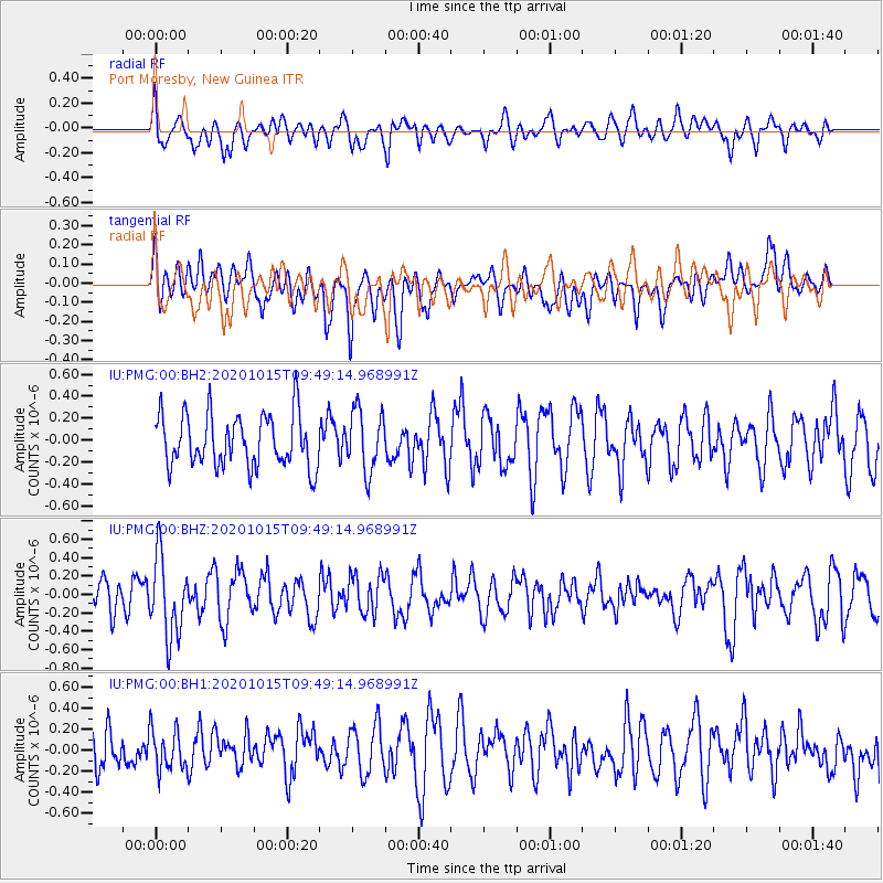
PMG Port Moresby, New Guinea - Earthquake Result Viewer
*The percent match for this event was below the threshold and hence no stack was calculated.
| Earthquake location: |
Southern Sumatra, Indonesia |
| Earthquake latitude/longitude: |
-3.2/100.3 |
| Earthquake time(UTC): |
2020/10/15 (289) 09:41:15 GMT |
| Earthquake Depth: |
10 km |
| Earthquake Magnitude: |
5.2 Mww |
| Earthquake Catalog/Contributor: |
NEIC PDE/us |
|
| Network: |
IU Global Seismograph Network (GSN - IRIS/USGS) |
| Station: |
PMG Port Moresby, New Guinea |
| Lat/Lon: |
9.40 S/147.16 E |
| Elevation: |
90 m |
|
| Distance: |
46.9 deg |
| Az: |
99.802 deg |
| Baz: |
274.375 deg |
| Ray Param: |
$rayparam |
*The percent match for this event was below the threshold and hence was not used in the summary stack. |
|
| Radial Match: |
67.32224 % |
| Radial Bump: |
400 |
| Transverse Match: |
59.661674 % |
| Transverse Bump: |
400 |
| SOD ConfigId: |
22732711 |
| Insert Time: |
2020-10-29 09:45:45.259 +0000 |
| GWidth: |
2.5 |
| Max Bumps: |
400 |
| Tol: |
0.001 |
|
Signal To Noise
| Channel | StoN | STA | LTA |
| IU:PMG:00:BHZ:20201015T09:49:14.968991Z | 2.2634046 | 4.334643E-7 | 1.9150987E-7 |
| IU:PMG:00:BH1:20201015T09:49:14.968991Z | 0.80471385 | 1.9393379E-7 | 2.409972E-7 |
| IU:PMG:00:BH2:20201015T09:49:14.968991Z | 1.1713729 | 2.783514E-7 | 2.3762836E-7 |
| Arrivals |
| Ps | |
| PpPs | |
| PsPs/PpSs | |


