You are here: Home > Network List > PM - Portuguese National Seismic Network Stations List
> Station PESTR PM.PESTR > Earthquake Result Viewer
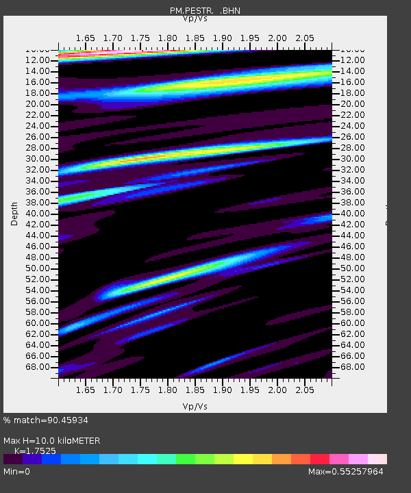
PESTR PM.PESTR - Earthquake Result Viewer
| Earthquake location: |
Western Brazil |
| Earthquake latitude/longitude: |
-8.1/-71.3 |
| Earthquake time(UTC): |
2007/07/21 (202) 13:27:04 GMT |
| Earthquake Depth: |
645 km |
| Earthquake Magnitude: |
6.2 MB, 6.1 MW, 6.0 MW |
| Earthquake Catalog/Contributor: |
WHDF/NEIC |
|
| Network: |
PM Portuguese National Seismic Network |
| Station: |
PESTR PM.PESTR |
| Lat/Lon: |
38.87 N/7.59 W |
| Elevation: |
410 m |
|
| Distance: |
75.2 deg |
| Az: |
46.355 deg |
| Baz: |
246.599 deg |
| Ray Param: |
0.049648434 |
| Estimated Moho Depth: |
10.0 km |
| Estimated Crust Vp/Vs: |
1.75 |
| Assumed Crust Vp: |
6.276 km/s |
| Estimated Crust Vs: |
3.581 km/s |
| Estimated Crust Poisson's Ratio: |
0.26 |
|
| Radial Match: |
90.45934 % |
| Radial Bump: |
400 |
| Transverse Match: |
87.67907 % |
| Transverse Bump: |
400 |
| SOD ConfigId: |
2564 |
| Insert Time: |
2010-03-09 02:01:03.307 +0000 |
| GWidth: |
2.5 |
| Max Bumps: |
400 |
| Tol: |
0.001 |
|

Signal To Noise
| Channel | StoN | STA | LTA |
| PM:PESTR: :BHN:20070721T13:37:12.245022Z | 14.402359 | 9.1759335E-7 | 6.3711326E-8 |
| PM:PESTR: :BHE:20070721T13:37:12.204006Z | 21.3728 | 1.3641651E-6 | 6.382715E-8 |
| PM:PESTR: :BHZ:20070721T13:37:12.214016Z | 54.758663 | 3.8262174E-6 | 6.98742E-8 |
| Arrivals |
| Ps | 1.2 SECOND |
| PpPs | 4.3 SECOND |
| PsPs/PpSs | 5.5 SECOND |


