You are here: Home > Network List > GM - US Geological Survey Networks Stations List
> Station IWM01 Jericho 2M Well Monitoring Station > Earthquake Result Viewer
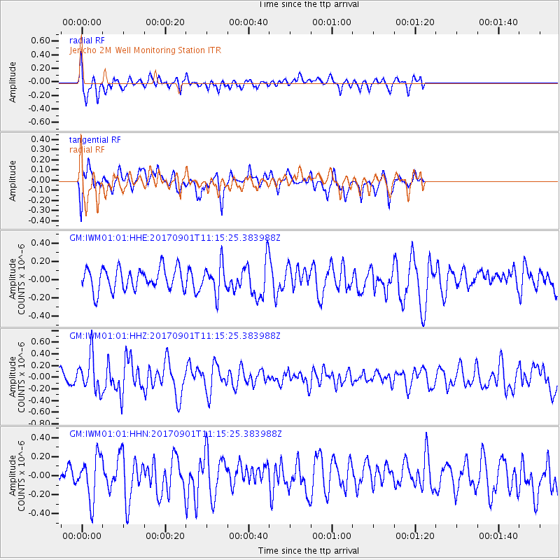
IWM01 Jericho 2M Well Monitoring Station - Earthquake Result Viewer
*The percent match for this event was below the threshold and hence no stack was calculated.
| Earthquake location: |
Reykjanes Ridge |
| Earthquake latitude/longitude: |
57.0/-34.0 |
| Earthquake time(UTC): |
2017/09/01 (244) 11:07:37 GMT |
| Earthquake Depth: |
10 km |
| Earthquake Magnitude: |
5.7 Mww |
| Earthquake Catalog/Contributor: |
NEIC PDE/us |
|
| Network: |
GM US Geological Survey Networks |
| Station: |
IWM01 Jericho 2M Well Monitoring Station |
| Lat/Lon: |
36.73 N/96.53 W |
| Elevation: |
328 m |
|
| Distance: |
45.5 deg |
| Az: |
271.188 deg |
| Baz: |
42.85 deg |
| Ray Param: |
$rayparam |
*The percent match for this event was below the threshold and hence was not used in the summary stack. |
|
| Radial Match: |
45.07106 % |
| Radial Bump: |
400 |
| Transverse Match: |
61.370808 % |
| Transverse Bump: |
400 |
| SOD ConfigId: |
2307692 |
| Insert Time: |
2017-09-15 11:16:32.911 +0000 |
| GWidth: |
2.5 |
| Max Bumps: |
400 |
| Tol: |
0.001 |
|
Signal To Noise
| Channel | StoN | STA | LTA |
| GM:IWM01:01:HHZ:20170901T11:15:25.383988Z | 3.0872703 | 3.048212E-7 | 9.8734866E-8 |
| GM:IWM01:01:HHN:20170901T11:15:25.383988Z | 1.5871998 | 2.2987402E-7 | 1.4482993E-7 |
| GM:IWM01:01:HHE:20170901T11:15:25.383988Z | 1.3344463 | 1.6112567E-7 | 1.2074347E-7 |
| Arrivals |
| Ps | |
| PpPs | |
| PsPs/PpSs | |


