You are here: Home > Network List > PM - Portuguese National Seismic Network Stations List
> Station PESTR ESTREMOZ, PORTUGAL > Earthquake Result Viewer
PESTR ESTREMOZ, PORTUGAL - Earthquake Result Viewer
| Earthquake location: |
Norwegian Sea |
| Earthquake latitude/longitude: |
72.2/0.9 |
| Earthquake time(UTC): |
2009/08/20 (232) 06:35:04 GMT |
| Earthquake Depth: |
6.0 km |
| Earthquake Magnitude: |
5.9 MB, 5.7 MS, 6.0 MW, 6.0 MW |
| Earthquake Catalog/Contributor: |
WHDF/NEIC |
|
| Network: |
PM Portuguese National Seismic Network |
| Station: |
PESTR ESTREMOZ, PORTUGAL |
| Lat/Lon: |
38.87 N/7.59 W |
| Elevation: |
410 m |
|
| Distance: |
33.7 deg |
| Az: |
192.057 deg |
| Baz: |
4.721 deg |
| Ray Param: |
0.078102715 |
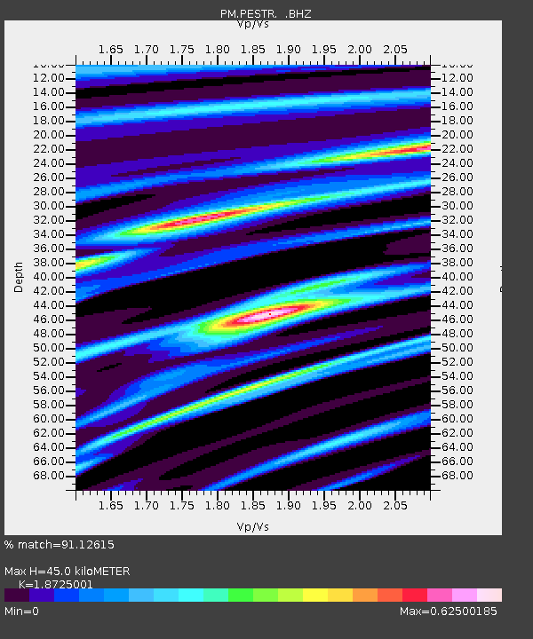
| Estimated Moho Depth: |
45.0 km |
| Estimated Crust Vp/Vs: |
1.87 |
| Assumed Crust Vp: |
6.276 km/s |
| Estimated Crust Vs: |
3.352 km/s |
| Estimated Crust Poisson's Ratio: |
0.30 |
|
| Radial Match: |
91.12615 % |
| Radial Bump: |
375 |
| Transverse Match: |
65.12503 % |
| Transverse Bump: |
400 |
| SOD ConfigId: |
2622 |
| Insert Time: |
2010-03-09 02:01:12.223 +0000 |
| GWidth: |
2.5 |
| Max Bumps: |
400 |
| Tol: |
0.001 |
|

Signal To Noise
| Channel | StoN | STA | LTA |
| PM:PESTR: :BHZ:20090820T06:41:15.405006Z | 19.984676 | 9.969805E-7 | 4.9887245E-8 |
| PM:PESTR: :BHN:20090820T06:41:15.36399Z | 23.622847 | 6.041314E-7 | 2.5574032E-8 |
| PM:PESTR: :BHE:20090820T06:41:15.405006Z | 3.5847306 | 1.2085658E-7 | 3.3714272E-8 |
| Arrivals |
| Ps | 6.7 SECOND |
| PpPs | 19 SECOND |
| PsPs/PpSs | 26 SECOND |


