You are here: Home > Network List > CI - Caltech Regional Seismic Network Stations List
> Station DGR Domenigoni Reservoir, California, USA > Earthquake Result Viewer
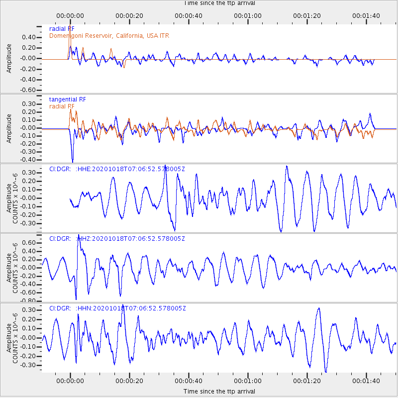
DGR Domenigoni Reservoir, California, USA - Earthquake Result Viewer
*The percent match for this event was below the threshold and hence no stack was calculated.
| Earthquake location: |
Near Coast Of Northern Peru |
| Earthquake latitude/longitude: |
-3.9/-81.8 |
| Earthquake time(UTC): |
2020/10/18 (292) 06:58:29 GMT |
| Earthquake Depth: |
10 km |
| Earthquake Magnitude: |
5.5 Mww |
| Earthquake Catalog/Contributor: |
NEIC PDE/us |
|
| Network: |
CI Caltech Regional Seismic Network |
| Station: |
DGR Domenigoni Reservoir, California, USA |
| Lat/Lon: |
33.65 N/117.01 W |
| Elevation: |
609 m |
|
| Distance: |
50.0 deg |
| Az: |
321.145 deg |
| Baz: |
131.377 deg |
| Ray Param: |
$rayparam |
*The percent match for this event was below the threshold and hence was not used in the summary stack. |
|
| Radial Match: |
65.96797 % |
| Radial Bump: |
400 |
| Transverse Match: |
71.23224 % |
| Transverse Bump: |
400 |
| SOD ConfigId: |
22732711 |
| Insert Time: |
2020-11-01 07:08:21.747 +0000 |
| GWidth: |
2.5 |
| Max Bumps: |
400 |
| Tol: |
0.001 |
|
Signal To Noise
| Channel | StoN | STA | LTA |
| CI:DGR: :HHZ:20201018T07:06:52.578005Z | 2.393833 | 4.3962672E-7 | 1.836497E-7 |
| CI:DGR: :HHN:20201018T07:06:52.578005Z | 0.9416832 | 1.3336293E-7 | 1.4162187E-7 |
| CI:DGR: :HHE:20201018T07:06:52.578005Z | 1.6138442 | 1.8884303E-7 | 1.1701442E-7 |
| Arrivals |
| Ps | |
| PpPs | |
| PsPs/PpSs | |


