You are here: Home > Network List > US - United States National Seismic Network Stations List
> Station HAWA Hanford, Washington, USA > Earthquake Result Viewer
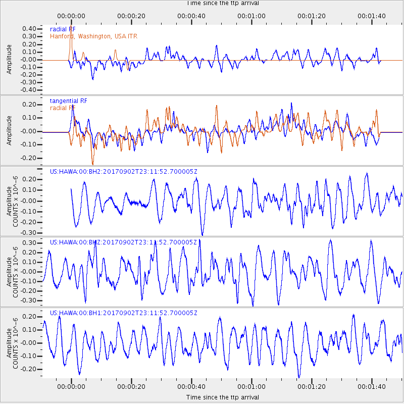
HAWA Hanford, Washington, USA - Earthquake Result Viewer
*The percent match for this event was below the threshold and hence no stack was calculated.
| Earthquake location: |
Mariana Islands |
| Earthquake latitude/longitude: |
14.0/146.7 |
| Earthquake time(UTC): |
2017/09/02 (245) 23:00:01 GMT |
| Earthquake Depth: |
10 km |
| Earthquake Magnitude: |
5.5 mb |
| Earthquake Catalog/Contributor: |
NEIC PDE/us |
|
| Network: |
US United States National Seismic Network |
| Station: |
HAWA Hanford, Washington, USA |
| Lat/Lon: |
46.39 N/119.53 W |
| Elevation: |
364 m |
|
| Distance: |
82.6 deg |
| Az: |
44.144 deg |
| Baz: |
282.399 deg |
| Ray Param: |
$rayparam |
*The percent match for this event was below the threshold and hence was not used in the summary stack. |
|
| Radial Match: |
51.256042 % |
| Radial Bump: |
400 |
| Transverse Match: |
46.29159 % |
| Transverse Bump: |
400 |
| SOD ConfigId: |
2307692 |
| Insert Time: |
2017-09-16 23:02:29.596 +0000 |
| GWidth: |
2.5 |
| Max Bumps: |
400 |
| Tol: |
0.001 |
|
Signal To Noise
| Channel | StoN | STA | LTA |
| US:HAWA:00:BHZ:20170902T23:11:52.700005Z | 0.8756639 | 1.1987548E-7 | 1.3689669E-7 |
| US:HAWA:00:BH1:20170902T23:11:52.700005Z | 1.5985342 | 1.3616958E-7 | 8.518402E-8 |
| US:HAWA:00:BH2:20170902T23:11:52.700005Z | 1.368469 | 1.1984525E-7 | 8.7576154E-8 |
| Arrivals |
| Ps | |
| PpPs | |
| PsPs/PpSs | |


