You are here: Home > Network List > CI - Caltech Regional Seismic Network Stations List
> Station GMR Granite Mountains Research Center > Earthquake Result Viewer
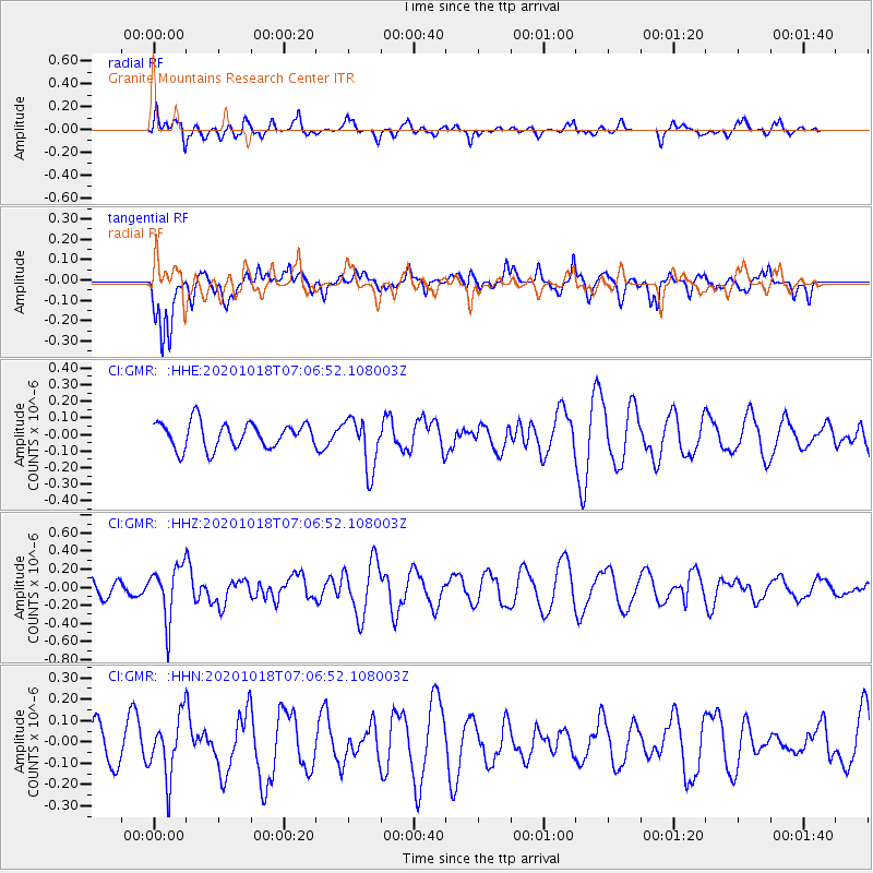
GMR Granite Mountains Research Center - Earthquake Result Viewer
*The percent match for this event was below the threshold and hence no stack was calculated.
| Earthquake location: |
Near Coast Of Northern Peru |
| Earthquake latitude/longitude: |
-3.9/-81.8 |
| Earthquake time(UTC): |
2020/10/18 (292) 06:58:29 GMT |
| Earthquake Depth: |
10 km |
| Earthquake Magnitude: |
5.5 Mww |
| Earthquake Catalog/Contributor: |
NEIC PDE/us |
|
| Network: |
CI Caltech Regional Seismic Network |
| Station: |
GMR Granite Mountains Research Center |
| Lat/Lon: |
34.78 N/115.66 W |
| Elevation: |
1326 m |
|
| Distance: |
49.9 deg |
| Az: |
323.222 deg |
| Baz: |
133.469 deg |
| Ray Param: |
$rayparam |
*The percent match for this event was below the threshold and hence was not used in the summary stack. |
|
| Radial Match: |
47.50642 % |
| Radial Bump: |
400 |
| Transverse Match: |
44.3523 % |
| Transverse Bump: |
400 |
| SOD ConfigId: |
22732711 |
| Insert Time: |
2020-11-01 07:08:32.186 +0000 |
| GWidth: |
2.5 |
| Max Bumps: |
400 |
| Tol: |
0.001 |
|
Signal To Noise
| Channel | StoN | STA | LTA |
| CI:GMR: :HHZ:20201018T07:06:52.108003Z | 2.4263325 | 2.9649945E-7 | 1.2220067E-7 |
| CI:GMR: :HHN:20201018T07:06:52.108003Z | 2.1139388 | 1.4020269E-7 | 6.632296E-8 |
| CI:GMR: :HHE:20201018T07:06:52.108003Z | 2.0051363 | 1.5533473E-7 | 7.7468414E-8 |
| Arrivals |
| Ps | |
| PpPs | |
| PsPs/PpSs | |


