You are here: Home > Network List > IU - Global Seismograph Network (GSN - IRIS/USGS) Stations List
> Station RSSD Black Hills, South Dakota, USA > Earthquake Result Viewer
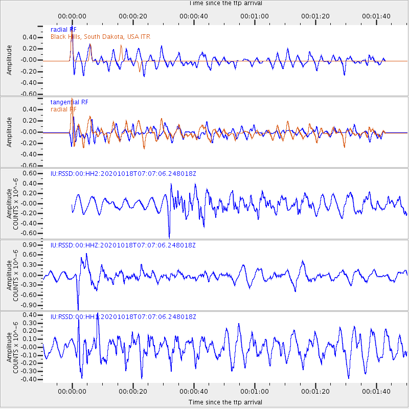
RSSD Black Hills, South Dakota, USA - Earthquake Result Viewer
*The percent match for this event was below the threshold and hence no stack was calculated.
| Earthquake location: |
Near Coast Of Northern Peru |
| Earthquake latitude/longitude: |
-3.9/-81.8 |
| Earthquake time(UTC): |
2020/10/18 (292) 06:58:29 GMT |
| Earthquake Depth: |
10 km |
| Earthquake Magnitude: |
5.5 Mww |
| Earthquake Catalog/Contributor: |
NEIC PDE/us |
|
| Network: |
IU Global Seismograph Network (GSN - IRIS/USGS) |
| Station: |
RSSD Black Hills, South Dakota, USA |
| Lat/Lon: |
44.12 N/104.04 W |
| Elevation: |
2090 m |
|
| Distance: |
51.8 deg |
| Az: |
339.747 deg |
| Baz: |
151.344 deg |
| Ray Param: |
$rayparam |
*The percent match for this event was below the threshold and hence was not used in the summary stack. |
|
| Radial Match: |
65.7036 % |
| Radial Bump: |
400 |
| Transverse Match: |
62.3861 % |
| Transverse Bump: |
400 |
| SOD ConfigId: |
22732711 |
| Insert Time: |
2020-11-01 07:14:30.118 +0000 |
| GWidth: |
2.5 |
| Max Bumps: |
400 |
| Tol: |
0.001 |
|
Signal To Noise
| Channel | StoN | STA | LTA |
| IU:RSSD:00:HHZ:20201018T07:07:06.248018Z | 5.057425 | 3.679807E-7 | 7.2760486E-8 |
| IU:RSSD:00:HH1:20201018T07:07:06.248018Z | 1.8354492 | 1.6609194E-7 | 9.049116E-8 |
| IU:RSSD:00:HH2:20201018T07:07:06.248018Z | 2.3924434 | 2.3046195E-7 | 9.632912E-8 |
| Arrivals |
| Ps | |
| PpPs | |
| PsPs/PpSs | |


