You are here: Home > Network List > TA - USArray Transportable Network (new EarthScope stations) Stations List
> Station G21K Allakaket, AK, USA > Earthquake Result Viewer
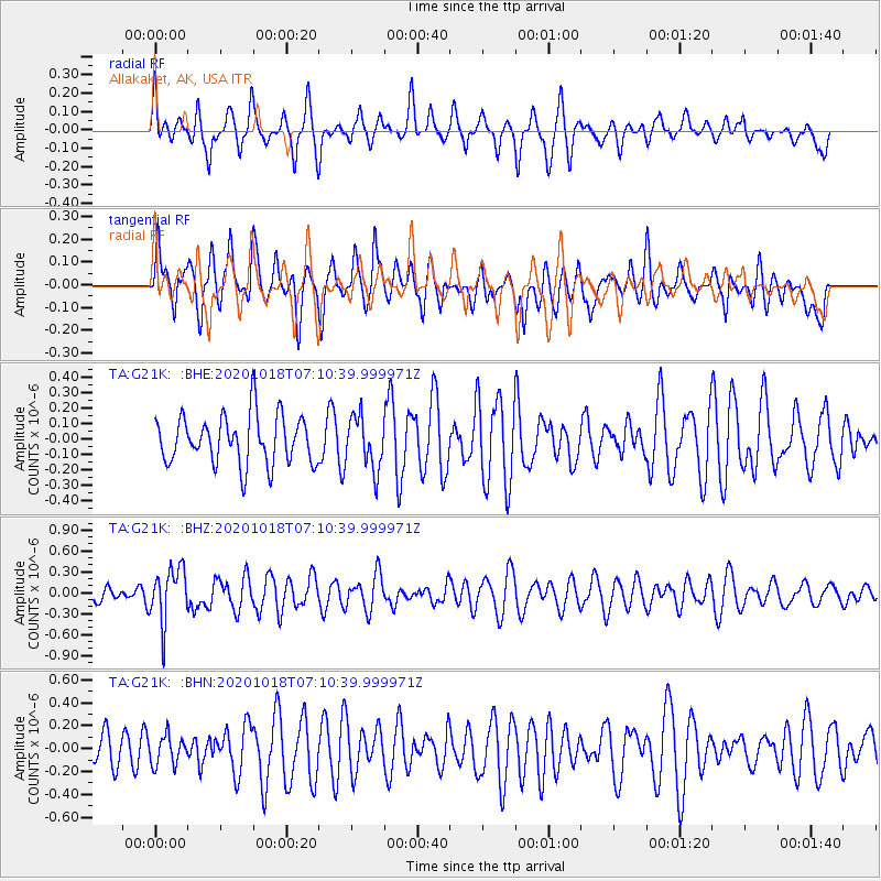
G21K Allakaket, AK, USA - Earthquake Result Viewer
*The percent match for this event was below the threshold and hence no stack was calculated.
| Earthquake location: |
Near Coast Of Northern Peru |
| Earthquake latitude/longitude: |
-3.9/-81.8 |
| Earthquake time(UTC): |
2020/10/18 (292) 06:58:29 GMT |
| Earthquake Depth: |
10 km |
| Earthquake Magnitude: |
5.5 Mww |
| Earthquake Catalog/Contributor: |
NEIC PDE/us |
|
| Network: |
TA USArray Transportable Network (new EarthScope stations) |
| Station: |
G21K Allakaket, AK, USA |
| Lat/Lon: |
66.52 N/153.51 W |
| Elevation: |
446 m |
|
| Distance: |
86.3 deg |
| Az: |
337.593 deg |
| Baz: |
108.38 deg |
| Ray Param: |
$rayparam |
*The percent match for this event was below the threshold and hence was not used in the summary stack. |
|
| Radial Match: |
55.850887 % |
| Radial Bump: |
352 |
| Transverse Match: |
55.327473 % |
| Transverse Bump: |
400 |
| SOD ConfigId: |
22732711 |
| Insert Time: |
2020-11-01 07:24:28.976 +0000 |
| GWidth: |
2.5 |
| Max Bumps: |
400 |
| Tol: |
0.001 |
|
Signal To Noise
| Channel | StoN | STA | LTA |
| TA:G21K: :BHZ:20201018T07:10:39.999971Z | 3.1859715 | 3.846229E-7 | 1.207239E-7 |
| TA:G21K: :BHN:20201018T07:10:39.999971Z | 0.8504129 | 1.2384642E-7 | 1.4563092E-7 |
| TA:G21K: :BHE:20201018T07:10:39.999971Z | 1.0746588 | 1.6883274E-7 | 1.5710359E-7 |
| Arrivals |
| Ps | |
| PpPs | |
| PsPs/PpSs | |


