You are here: Home > Network List > US - United States National Seismic Network Stations List
> Station AMTX Amarillo, Texas, USA > Earthquake Result Viewer
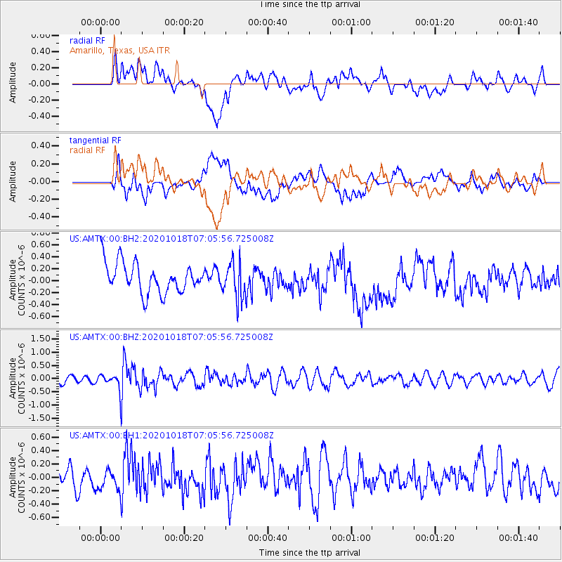
AMTX Amarillo, Texas, USA - Earthquake Result Viewer
*The percent match for this event was below the threshold and hence no stack was calculated.
| Earthquake location: |
Near Coast Of Northern Peru |
| Earthquake latitude/longitude: |
-3.9/-81.8 |
| Earthquake time(UTC): |
2020/10/18 (292) 06:58:29 GMT |
| Earthquake Depth: |
10 km |
| Earthquake Magnitude: |
5.5 Mww |
| Earthquake Catalog/Contributor: |
NEIC PDE/us |
|
| Network: |
US United States National Seismic Network |
| Station: |
AMTX Amarillo, Texas, USA |
| Lat/Lon: |
34.53 N/101.41 W |
| Elevation: |
1010 m |
|
| Distance: |
42.4 deg |
| Az: |
335.813 deg |
| Baz: |
150.321 deg |
| Ray Param: |
$rayparam |
*The percent match for this event was below the threshold and hence was not used in the summary stack. |
|
| Radial Match: |
47.16244 % |
| Radial Bump: |
400 |
| Transverse Match: |
54.446663 % |
| Transverse Bump: |
400 |
| SOD ConfigId: |
22732711 |
| Insert Time: |
2020-11-01 07:28:04.503 +0000 |
| GWidth: |
2.5 |
| Max Bumps: |
400 |
| Tol: |
0.001 |
|
Signal To Noise
| Channel | StoN | STA | LTA |
| US:AMTX:00:BHZ:20201018T07:05:56.725008Z | 1.6493956 | 2.9382224E-7 | 1.7813935E-7 |
| US:AMTX:00:BH1:20201018T07:05:56.725008Z | 1.3079449 | 1.5119814E-7 | 1.15599775E-7 |
| US:AMTX:00:BH2:20201018T07:05:56.725008Z | 0.5879984 | 1.5705373E-7 | 2.670989E-7 |
| Arrivals |
| Ps | |
| PpPs | |
| PsPs/PpSs | |


