You are here: Home > Network List > US - United States National Seismic Network Stations List
> Station DGMT Dagmar, Montana, USA > Earthquake Result Viewer
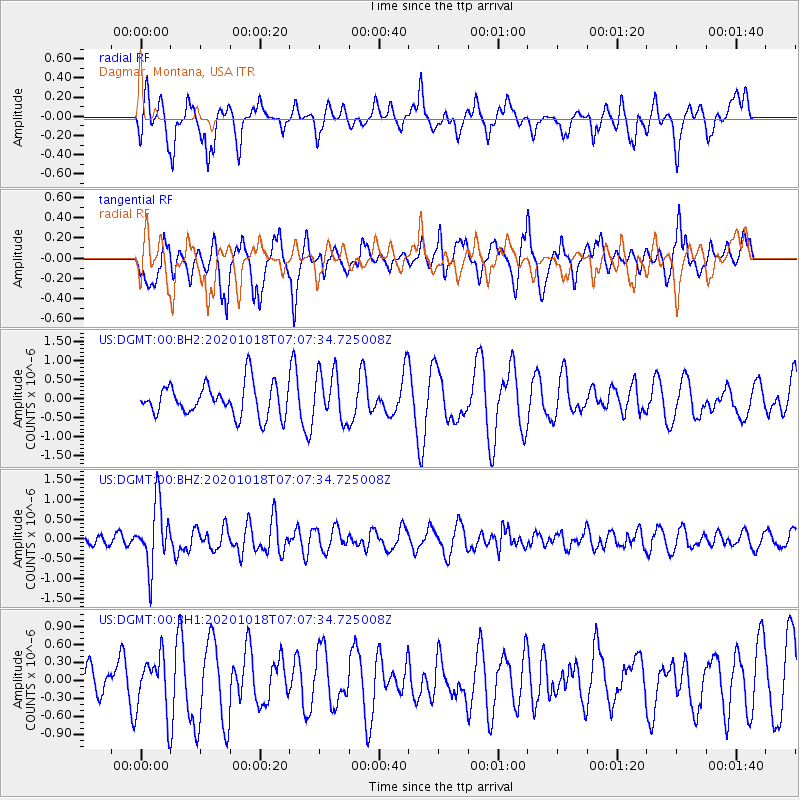
DGMT Dagmar, Montana, USA - Earthquake Result Viewer
*The percent match for this event was below the threshold and hence no stack was calculated.
| Earthquake location: |
Near Coast Of Northern Peru |
| Earthquake latitude/longitude: |
-3.9/-81.8 |
| Earthquake time(UTC): |
2020/10/18 (292) 06:58:29 GMT |
| Earthquake Depth: |
10 km |
| Earthquake Magnitude: |
5.5 Mww |
| Earthquake Catalog/Contributor: |
NEIC PDE/us |
|
| Network: |
US United States National Seismic Network |
| Station: |
DGMT Dagmar, Montana, USA |
| Lat/Lon: |
48.47 N/104.20 W |
| Elevation: |
0.0 m |
|
| Distance: |
55.7 deg |
| Az: |
342.158 deg |
| Baz: |
152.656 deg |
| Ray Param: |
$rayparam |
*The percent match for this event was below the threshold and hence was not used in the summary stack. |
|
| Radial Match: |
48.56484 % |
| Radial Bump: |
383 |
| Transverse Match: |
51.321198 % |
| Transverse Bump: |
400 |
| SOD ConfigId: |
22732711 |
| Insert Time: |
2020-11-01 07:28:15.643 +0000 |
| GWidth: |
2.5 |
| Max Bumps: |
400 |
| Tol: |
0.001 |
|
Signal To Noise
| Channel | StoN | STA | LTA |
| US:DGMT:00:BHZ:20201018T07:07:34.725008Z | 3.9416106 | 7.862105E-7 | 1.9946428E-7 |
| US:DGMT:00:BH1:20201018T07:07:34.725008Z | 0.6653898 | 4.787964E-7 | 7.1957277E-7 |
| US:DGMT:00:BH2:20201018T07:07:34.725008Z | 1.5030655 | 6.301644E-7 | 4.1925276E-7 |
| Arrivals |
| Ps | |
| PpPs | |
| PsPs/PpSs | |


