You are here: Home > Network List > US - United States National Seismic Network Stations List
> Station WMOK Wichita Mountains, Oklahoma, USA > Earthquake Result Viewer
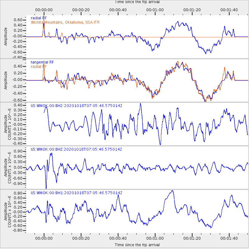
WMOK Wichita Mountains, Oklahoma, USA - Earthquake Result Viewer
*The percent match for this event was below the threshold and hence no stack was calculated.
| Earthquake location: |
Near Coast Of Northern Peru |
| Earthquake latitude/longitude: |
-3.9/-81.8 |
| Earthquake time(UTC): |
2020/10/18 (292) 06:58:29 GMT |
| Earthquake Depth: |
10 km |
| Earthquake Magnitude: |
5.5 Mww |
| Earthquake Catalog/Contributor: |
NEIC PDE/us |
|
| Network: |
US United States National Seismic Network |
| Station: |
WMOK Wichita Mountains, Oklahoma, USA |
| Lat/Lon: |
34.74 N/98.78 W |
| Elevation: |
486 m |
|
| Distance: |
41.6 deg |
| Az: |
338.82 deg |
| Baz: |
154.042 deg |
| Ray Param: |
$rayparam |
*The percent match for this event was below the threshold and hence was not used in the summary stack. |
|
| Radial Match: |
49.8253 % |
| Radial Bump: |
400 |
| Transverse Match: |
44.485607 % |
| Transverse Bump: |
400 |
| SOD ConfigId: |
22732711 |
| Insert Time: |
2020-11-01 07:29:04.951 +0000 |
| GWidth: |
2.5 |
| Max Bumps: |
400 |
| Tol: |
0.001 |
|
Signal To Noise
| Channel | StoN | STA | LTA |
| US:WMOK:00:BHZ:20201018T07:05:46.575014Z | 4.1675634 | 5.1863276E-7 | 1.2444508E-7 |
| US:WMOK:00:BH1:20201018T07:05:46.575014Z | 0.81668335 | 2.189019E-7 | 2.6803767E-7 |
| US:WMOK:00:BH2:20201018T07:05:46.575014Z | 1.4747927 | 1.8532553E-7 | 1.2566208E-7 |
| Arrivals |
| Ps | |
| PpPs | |
| PsPs/PpSs | |


