You are here: Home > Network List > UU - University of Utah Regional Network Stations List
> Station FORU South Mineral Mountains, UT, USA > Earthquake Result Viewer
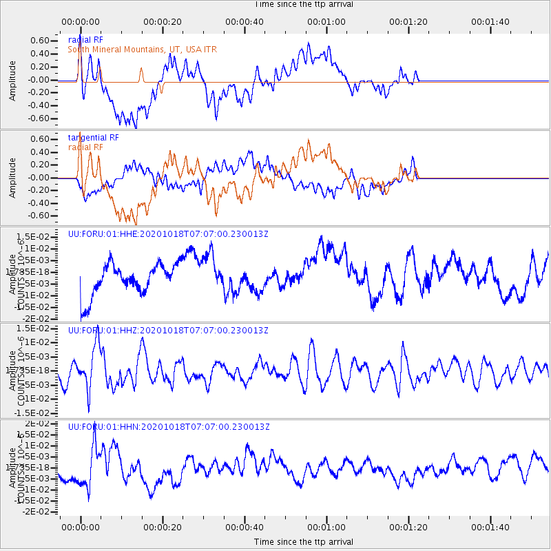
FORU South Mineral Mountains, UT, USA - Earthquake Result Viewer
*The percent match for this event was below the threshold and hence no stack was calculated.
| Earthquake location: |
Near Coast Of Northern Peru |
| Earthquake latitude/longitude: |
-3.9/-81.8 |
| Earthquake time(UTC): |
2020/10/18 (292) 06:58:29 GMT |
| Earthquake Depth: |
10 km |
| Earthquake Magnitude: |
5.5 Mww |
| Earthquake Catalog/Contributor: |
NEIC PDE/us |
|
| Network: |
UU University of Utah Regional Network |
| Station: |
FORU South Mineral Mountains, UT, USA |
| Lat/Lon: |
38.46 N/112.86 W |
| Elevation: |
1840 m |
|
| Distance: |
51.0 deg |
| Az: |
328.625 deg |
| Baz: |
138.575 deg |
| Ray Param: |
$rayparam |
*The percent match for this event was below the threshold and hence was not used in the summary stack. |
|
| Radial Match: |
60.817863 % |
| Radial Bump: |
400 |
| Transverse Match: |
31.314234 % |
| Transverse Bump: |
400 |
| SOD ConfigId: |
22732711 |
| Insert Time: |
2020-11-01 07:29:26.702 +0000 |
| GWidth: |
2.5 |
| Max Bumps: |
400 |
| Tol: |
0.001 |
|
Signal To Noise
| Channel | StoN | STA | LTA |
| UU:FORU:01:HHZ:20201018T07:07:00.230013Z | 4.785313 | 7.865633E-9 | 1.6437028E-9 |
| UU:FORU:01:HHN:20201018T07:07:00.230013Z | 2.5982132 | 9.418611E-9 | 3.625034E-9 |
| UU:FORU:01:HHE:20201018T07:07:00.230013Z | 1.2586329 | 8.360059E-9 | 6.6421744E-9 |
| Arrivals |
| Ps | |
| PpPs | |
| PsPs/PpSs | |


