You are here: Home > Network List > WY - Yellowstone Wyoming Seismic Network Stations List
> Station YHH Holmes Hill, YNP, WY, USA > Earthquake Result Viewer
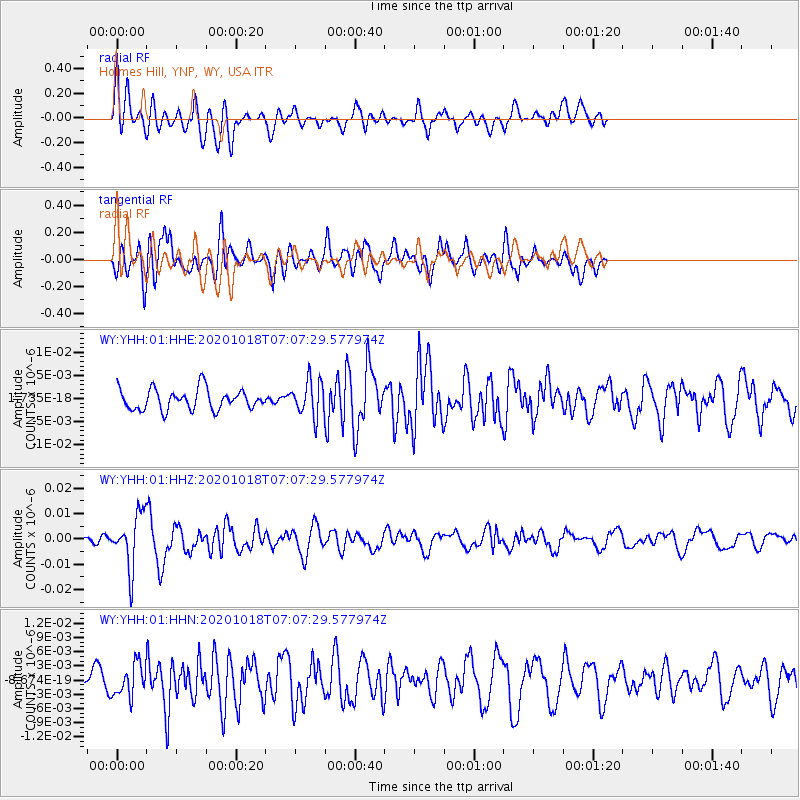
YHH Holmes Hill, YNP, WY, USA - Earthquake Result Viewer
*The percent match for this event was below the threshold and hence no stack was calculated.
| Earthquake location: |
Near Coast Of Northern Peru |
| Earthquake latitude/longitude: |
-3.9/-81.8 |
| Earthquake time(UTC): |
2020/10/18 (292) 06:58:29 GMT |
| Earthquake Depth: |
10 km |
| Earthquake Magnitude: |
5.5 Mww |
| Earthquake Catalog/Contributor: |
NEIC PDE/us |
|
| Network: |
WY Yellowstone Wyoming Seismic Network |
| Station: |
YHH Holmes Hill, YNP, WY, USA |
| Lat/Lon: |
44.79 N/110.85 W |
| Elevation: |
2717 m |
|
| Distance: |
55.0 deg |
| Az: |
335.062 deg |
| Baz: |
143.788 deg |
| Ray Param: |
$rayparam |
*The percent match for this event was below the threshold and hence was not used in the summary stack. |
|
| Radial Match: |
59.45256 % |
| Radial Bump: |
400 |
| Transverse Match: |
54.645687 % |
| Transverse Bump: |
400 |
| SOD ConfigId: |
22732711 |
| Insert Time: |
2020-11-01 07:31:50.024 +0000 |
| GWidth: |
2.5 |
| Max Bumps: |
400 |
| Tol: |
0.001 |
|
Signal To Noise
| Channel | StoN | STA | LTA |
| WY:YHH:01:HHZ:20201018T07:07:29.577974Z | 3.3495414 | 1.0471247E-8 | 3.1261733E-9 |
| WY:YHH:01:HHN:20201018T07:07:29.577974Z | 0.9770887 | 3.335856E-9 | 3.414077E-9 |
| WY:YHH:01:HHE:20201018T07:07:29.577974Z | 1.7025423 | 3.793477E-9 | 2.228125E-9 |
| Arrivals |
| Ps | |
| PpPs | |
| PsPs/PpSs | |


