You are here: Home > Network List > GO - National Seismic Network of Georgia Stations List
> Station TBLG Delisi, Georgia > Earthquake Result Viewer
TBLG Delisi, Georgia - Earthquake Result Viewer

| Earthquake location: |
Southern Sumatra, Indonesia |
| Earthquake latitude/longitude: |
-3.4/100.3 |
| Earthquake time(UTC): |
2020/10/19 (293) 07:31:28 GMT |
| Earthquake Depth: |
10 km |
| Earthquake Magnitude: |
5.6 Mww |
| Earthquake Catalog/Contributor: |
NEIC PDE/us |
|
| Network: |
GO National Seismic Network of Georgia |
| Station: |
TBLG Delisi, Georgia |
| Lat/Lon: |
41.73 N/44.74 E |
| Elevation: |
510 m |
|
| Distance: |
67.4 deg |
| Az: |
318.058 deg |
| Baz: |
116.945 deg |
| Ray Param: |
0.056989394 |
| Estimated Moho Depth: |
47.0 km |
| Estimated Crust Vp/Vs: |
1.75 |
| Assumed Crust Vp: |
6.291 km/s |
| Estimated Crust Vs: |
3.59 km/s |
| Estimated Crust Poisson's Ratio: |
0.26 |
|
| Radial Match: |
81.85116 % |
| Radial Bump: |
400 |
| Transverse Match: |
78.303734 % |
| Transverse Bump: |
320 |
| SOD ConfigId: |
22732711 |
| Insert Time: |
2020-11-02 07:34:42.556 +0000 |
| GWidth: |
2.5 |
| Max Bumps: |
400 |
| Tol: |
0.001 |
|
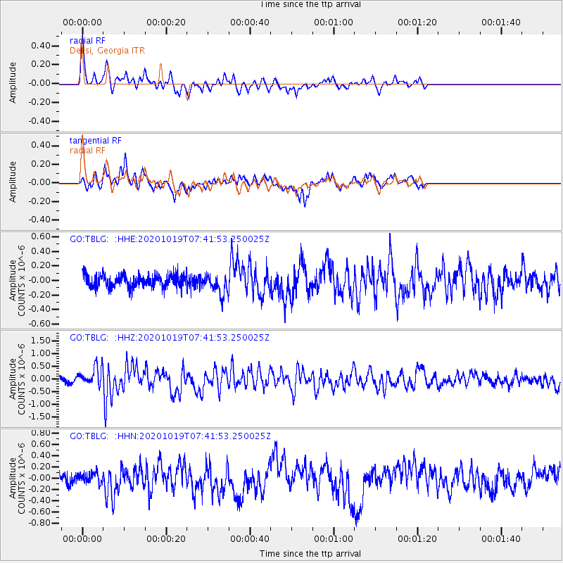
Signal To Noise
| Channel | StoN | STA | LTA |
| GO:TBLG: :HHZ:20201019T07:41:53.250025Z | 3.227944 | 3.6319955E-7 | 1.12517306E-7 |
| GO:TBLG: :HHN:20201019T07:41:53.250025Z | 0.7097106 | 9.011193E-8 | 1.2696997E-7 |
| GO:TBLG: :HHE:20201019T07:41:53.250025Z | 1.6552218 | 1.4104815E-7 | 8.521405E-8 |
| Arrivals |
| Ps | 5.8 SECOND |
| PpPs | 20 SECOND |
| PsPs/PpSs | 26 SECOND |


