You are here: Home > Network List > IU - Global Seismograph Network (GSN - IRIS/USGS) Stations List
> Station RSSD Black Hills, South Dakota, USA > Earthquake Result Viewer
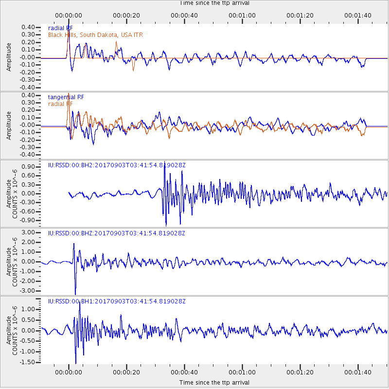
RSSD Black Hills, South Dakota, USA - Earthquake Result Viewer
*The percent match for this event was below the threshold and hence no stack was calculated.
| Earthquake location: |
North Korea |
| Earthquake latitude/longitude: |
41.3/129.0 |
| Earthquake time(UTC): |
2017/09/03 (246) 03:30:01 GMT |
| Earthquake Depth: |
0.0 km |
| Earthquake Magnitude: |
6.3 mb |
| Earthquake Catalog/Contributor: |
NEIC PDE/us |
|
| Network: |
IU Global Seismograph Network (GSN - IRIS/USGS) |
| Station: |
RSSD Black Hills, South Dakota, USA |
| Lat/Lon: |
44.12 N/104.04 W |
| Elevation: |
2090 m |
|
| Distance: |
82.5 deg |
| Az: |
35.5 deg |
| Baz: |
322.618 deg |
| Ray Param: |
$rayparam |
*The percent match for this event was below the threshold and hence was not used in the summary stack. |
|
| Radial Match: |
75.76849 % |
| Radial Bump: |
400 |
| Transverse Match: |
73.40135 % |
| Transverse Bump: |
400 |
| SOD ConfigId: |
2307692 |
| Insert Time: |
2017-09-17 03:35:52.121 +0000 |
| GWidth: |
2.5 |
| Max Bumps: |
400 |
| Tol: |
0.001 |
|
Signal To Noise
| Channel | StoN | STA | LTA |
| IU:RSSD:00:BHZ:20170903T03:41:54.819028Z | 11.331902 | 9.923131E-7 | 8.75681E-8 |
| IU:RSSD:00:BH1:20170903T03:41:54.819028Z | 5.7692885 | 5.555095E-7 | 9.628734E-8 |
| IU:RSSD:00:BH2:20170903T03:41:54.819028Z | 6.7428126 | 4.021423E-7 | 5.9640136E-8 |
| Arrivals |
| Ps | |
| PpPs | |
| PsPs/PpSs | |


