You are here: Home > Network List > AU - Australian Seismological Centre Stations List
> Station LAROZ Larrimah, NT > Earthquake Result Viewer
LAROZ Larrimah, NT - Earthquake Result Viewer
| Earthquake location: |
South Of Alaska |
| Earthquake latitude/longitude: |
54.7/-159.6 |
| Earthquake time(UTC): |
2020/10/19 (293) 20:54:40 GMT |
| Earthquake Depth: |
41 km |
| Earthquake Magnitude: |
7.4 Mi |
| Earthquake Catalog/Contributor: |
NEIC PDE/at |
|
| Network: |
AU Australian Seismological Centre |
| Station: |
LAROZ Larrimah, NT |
| Lat/Lon: |
15.57 S/133.21 E |
| Elevation: |
188 m |
|
| Distance: |
90.0 deg |
| Az: |
242.662 deg |
| Baz: |
32.376 deg |
| Ray Param: |
0.041723028 |
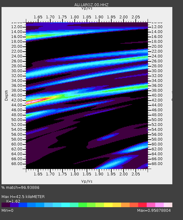
| Estimated Moho Depth: |
42.5 km |
| Estimated Crust Vp/Vs: |
1.62 |
| Assumed Crust Vp: |
6.61 km/s |
| Estimated Crust Vs: |
4.08 km/s |
| Estimated Crust Poisson's Ratio: |
0.19 |
|
| Radial Match: |
96.93886 % |
| Radial Bump: |
329 |
| Transverse Match: |
93.375725 % |
| Transverse Bump: |
400 |
| SOD ConfigId: |
22732711 |
| Insert Time: |
2020-11-02 20:56:25.803 +0000 |
| GWidth: |
2.5 |
| Max Bumps: |
400 |
| Tol: |
0.001 |
|

Signal To Noise
| Channel | StoN | STA | LTA |
| AU:LAROZ:00:HHZ:20201019T21:07:03.929993Z | 10.239255 | 3.056601E-7 | 2.9851794E-8 |
| AU:LAROZ:00:HHN:20201019T21:07:03.929993Z | 3.4219291 | 8.612984E-8 | 2.5169966E-8 |
| AU:LAROZ:00:HHE:20201019T21:07:03.929993Z | 1.9122932 | 3.9909555E-8 | 2.0869997E-8 |
| Arrivals |
| Ps | 4.1 SECOND |
| PpPs | 16 SECOND |
| PsPs/PpSs | 21 SECOND |


