You are here: Home > Network List > AZ - ANZA Regional Network Stations List
> Station LVA2 AZ.LVA2 > Earthquake Result Viewer
LVA2 AZ.LVA2 - Earthquake Result Viewer
| Earthquake location: |
South Of Alaska |
| Earthquake latitude/longitude: |
54.7/-159.6 |
| Earthquake time(UTC): |
2020/10/19 (293) 20:54:40 GMT |
| Earthquake Depth: |
41 km |
| Earthquake Magnitude: |
7.4 Mi |
| Earthquake Catalog/Contributor: |
NEIC PDE/at |
|
| Network: |
AZ ANZA Regional Network |
| Station: |
LVA2 AZ.LVA2 |
| Lat/Lon: |
33.35 N/116.56 W |
| Elevation: |
1435 m |
|
| Distance: |
36.8 deg |
| Az: |
107.486 deg |
| Baz: |
318.547 deg |
| Ray Param: |
0.07641887 |
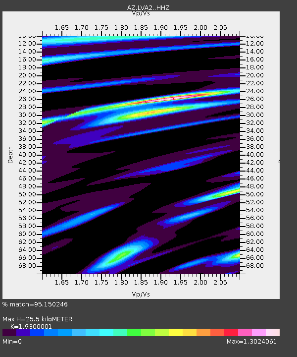
| Estimated Moho Depth: |
25.5 km |
| Estimated Crust Vp/Vs: |
1.93 |
| Assumed Crust Vp: |
6.264 km/s |
| Estimated Crust Vs: |
3.245 km/s |
| Estimated Crust Poisson's Ratio: |
0.32 |
|
| Radial Match: |
95.150246 % |
| Radial Bump: |
245 |
| Transverse Match: |
83.87358 % |
| Transverse Bump: |
374 |
| SOD ConfigId: |
22732711 |
| Insert Time: |
2020-11-02 20:56:40.415 +0000 |
| GWidth: |
2.5 |
| Max Bumps: |
400 |
| Tol: |
0.001 |
|

Signal To Noise
| Channel | StoN | STA | LTA |
| AZ:LVA2: :HHZ:20201019T21:01:13.52301Z | 5.167955 | 7.0233693E-7 | 1.359023E-7 |
| AZ:LVA2: :HHN:20201019T21:01:13.52301Z | 2.2186966 | 5.70514E-7 | 2.5713925E-7 |
| AZ:LVA2: :HHE:20201019T21:01:13.52301Z | 1.1925669 | 3.0307814E-7 | 2.5413934E-7 |
| Arrivals |
| Ps | 4.0 SECOND |
| PpPs | 11 SECOND |
| PsPs/PpSs | 15 SECOND |


