You are here: Home > Network List > CA - Catalan Seismic Network Stations List
> Station CPAL Palau-saverdera > Earthquake Result Viewer
CPAL Palau-saverdera - Earthquake Result Viewer
| Earthquake location: |
South Of Alaska |
| Earthquake latitude/longitude: |
54.7/-159.6 |
| Earthquake time(UTC): |
2020/10/19 (293) 20:54:40 GMT |
| Earthquake Depth: |
41 km |
| Earthquake Magnitude: |
7.4 Mi |
| Earthquake Catalog/Contributor: |
NEIC PDE/at |
|
| Network: |
CA Catalan Seismic Network |
| Station: |
CPAL Palau-saverdera |
| Lat/Lon: |
42.31 N/3.16 E |
| Elevation: |
212 m |
|
| Distance: |
82.3 deg |
| Az: |
12.81 deg |
| Baz: |
350.0 deg |
| Ray Param: |
0.046935312 |
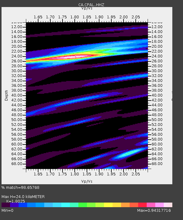
| Estimated Moho Depth: |
24.0 km |
| Estimated Crust Vp/Vs: |
1.80 |
| Assumed Crust Vp: |
6.264 km/s |
| Estimated Crust Vs: |
3.475 km/s |
| Estimated Crust Poisson's Ratio: |
0.28 |
|
| Radial Match: |
98.65768 % |
| Radial Bump: |
229 |
| Transverse Match: |
92.64776 % |
| Transverse Bump: |
400 |
| SOD ConfigId: |
22732711 |
| Insert Time: |
2020-11-02 20:57:46.911 +0000 |
| GWidth: |
2.5 |
| Max Bumps: |
400 |
| Tol: |
0.001 |
|

Signal To Noise
| Channel | StoN | STA | LTA |
| CA:CPAL: :HHZ:20201019T21:06:26.070007Z | 4.073894 | 1.1380453E-6 | 2.7935073E-7 |
| CA:CPAL: :HHN:20201019T21:06:26.070007Z | 1.7793508 | 3.5694552E-7 | 2.0060436E-7 |
| CA:CPAL: :HHE:20201019T21:06:26.070007Z | 0.6643806 | 1.3880575E-7 | 2.0892504E-7 |
| Arrivals |
| Ps | 3.2 SECOND |
| PpPs | 10 SECOND |
| PsPs/PpSs | 14 SECOND |


