You are here: Home > Network List > CA - Catalan Seismic Network Stations List
> Station EBR Ebre > Earthquake Result Viewer
EBR Ebre - Earthquake Result Viewer

| Earthquake location: |
South Of Alaska |
| Earthquake latitude/longitude: |
54.7/-159.6 |
| Earthquake time(UTC): |
2020/10/19 (293) 20:54:40 GMT |
| Earthquake Depth: |
41 km |
| Earthquake Magnitude: |
7.4 Mi |
| Earthquake Catalog/Contributor: |
NEIC PDE/at |
|
| Network: |
CA Catalan Seismic Network |
| Station: |
EBR Ebre |
| Lat/Lon: |
40.82 N/0.49 E |
| Elevation: |
36 m |
|
| Distance: |
83.4 deg |
| Az: |
15.072 deg |
| Baz: |
348.518 deg |
| Ray Param: |
0.04617625 |
| Estimated Moho Depth: |
18.0 km |
| Estimated Crust Vp/Vs: |
1.82 |
| Assumed Crust Vp: |
6.391 km/s |
| Estimated Crust Vs: |
3.511 km/s |
| Estimated Crust Poisson's Ratio: |
0.28 |
|
| Radial Match: |
86.36445 % |
| Radial Bump: |
400 |
| Transverse Match: |
73.508865 % |
| Transverse Bump: |
400 |
| SOD ConfigId: |
22732711 |
| Insert Time: |
2020-11-02 20:57:51.122 +0000 |
| GWidth: |
2.5 |
| Max Bumps: |
400 |
| Tol: |
0.001 |
|
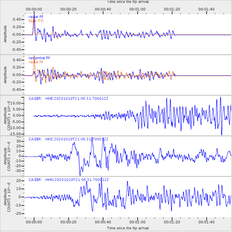
Signal To Noise
| Channel | StoN | STA | LTA |
| CA:EBR: :HHZ:20201019T21:06:31.700012Z | 7.068921 | 1.5156519E-6 | 2.1441065E-7 |
| CA:EBR: :HHN:20201019T21:06:31.700012Z | 1.7947961 | 6.6089234E-7 | 3.6822698E-7 |
| CA:EBR: :HHE:20201019T21:06:31.700012Z | 1.2484109 | 3.7382839E-7 | 2.9944337E-7 |
| Arrivals |
| Ps | 2.4 SECOND |
| PpPs | 7.7 SECOND |
| PsPs/PpSs | 10 SECOND |


