You are here: Home > Network List > CI - Caltech Regional Seismic Network Stations List
> Station BAR Barrett, Tecate, CA, USA > Earthquake Result Viewer
BAR Barrett, Tecate, CA, USA - Earthquake Result Viewer
| Earthquake location: |
South Of Alaska |
| Earthquake latitude/longitude: |
54.7/-159.6 |
| Earthquake time(UTC): |
2020/10/19 (293) 20:54:40 GMT |
| Earthquake Depth: |
41 km |
| Earthquake Magnitude: |
7.4 Mi |
| Earthquake Catalog/Contributor: |
NEIC PDE/at |
|
| Network: |
CI Caltech Regional Seismic Network |
| Station: |
BAR Barrett, Tecate, CA, USA |
| Lat/Lon: |
32.68 N/116.67 W |
| Elevation: |
521 m |
|
| Distance: |
37.2 deg |
| Az: |
108.334 deg |
| Baz: |
319.164 deg |
| Ray Param: |
0.076162234 |
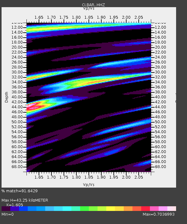
| Estimated Moho Depth: |
43.25 km |
| Estimated Crust Vp/Vs: |
1.61 |
| Assumed Crust Vp: |
6.264 km/s |
| Estimated Crust Vs: |
3.903 km/s |
| Estimated Crust Poisson's Ratio: |
0.18 |
|
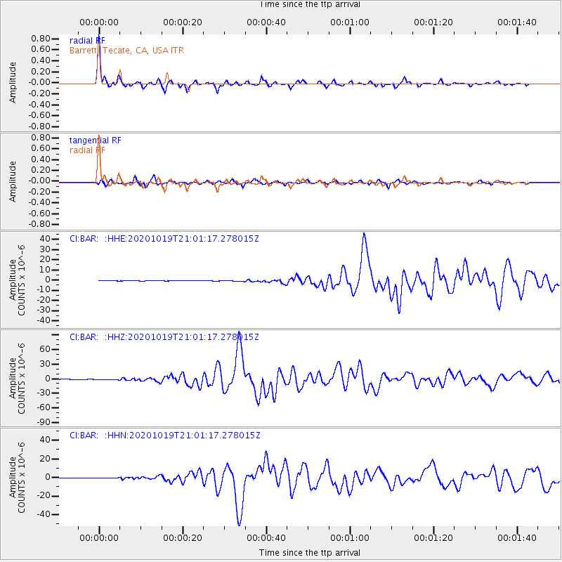
| Radial Match: |
91.6429 % |
| Radial Bump: |
249 |
| Transverse Match: |
84.16943 % |
| Transverse Bump: |
335 |
| SOD ConfigId: |
22732711 |
| Insert Time: |
2020-11-02 20:58:09.498 +0000 |
| GWidth: |
2.5 |
| Max Bumps: |
400 |
| Tol: |
0.001 |
|
Signal To Noise
| Channel | StoN | STA | LTA |
| CI:BAR: :HHZ:20201019T21:01:17.278015Z | 3.267882 | 6.5603587E-7 | 2.0075262E-7 |
| CI:BAR: :HHN:20201019T21:01:17.278015Z | 3.158068 | 3.0413446E-7 | 9.6303964E-8 |
| CI:BAR: :HHE:20201019T21:01:17.278015Z | 4.0465703 | 3.232149E-7 | 7.9873786E-8 |
| Arrivals |
| Ps | 4.5 SECOND |
| PpPs | 17 SECOND |
| PsPs/PpSs | 21 SECOND |


