You are here: Home > Network List > CI - Caltech Regional Seismic Network Stations List
> Station CIA CIA, Avalon Catalina Island, CA, USA > Earthquake Result Viewer
CIA CIA, Avalon Catalina Island, CA, USA - Earthquake Result Viewer
| Earthquake location: |
South Of Alaska |
| Earthquake latitude/longitude: |
54.7/-159.6 |
| Earthquake time(UTC): |
2020/10/19 (293) 20:54:40 GMT |
| Earthquake Depth: |
41 km |
| Earthquake Magnitude: |
7.4 Mi |
| Earthquake Catalog/Contributor: |
NEIC PDE/at |
|
| Network: |
CI Caltech Regional Seismic Network |
| Station: |
CIA CIA, Avalon Catalina Island, CA, USA |
| Lat/Lon: |
33.40 N/118.41 W |
| Elevation: |
467 m |
|
| Distance: |
35.7 deg |
| Az: |
109.402 deg |
| Baz: |
319.078 deg |
| Ray Param: |
0.07698636 |
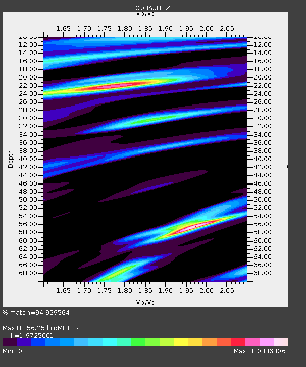
| Estimated Moho Depth: |
56.25 km |
| Estimated Crust Vp/Vs: |
1.97 |
| Assumed Crust Vp: |
6.048 km/s |
| Estimated Crust Vs: |
3.066 km/s |
| Estimated Crust Poisson's Ratio: |
0.33 |
|
| Radial Match: |
94.959564 % |
| Radial Bump: |
255 |
| Transverse Match: |
79.0985 % |
| Transverse Bump: |
400 |
| SOD ConfigId: |
22732711 |
| Insert Time: |
2020-11-02 20:58:21.010 +0000 |
| GWidth: |
2.5 |
| Max Bumps: |
400 |
| Tol: |
0.001 |
|
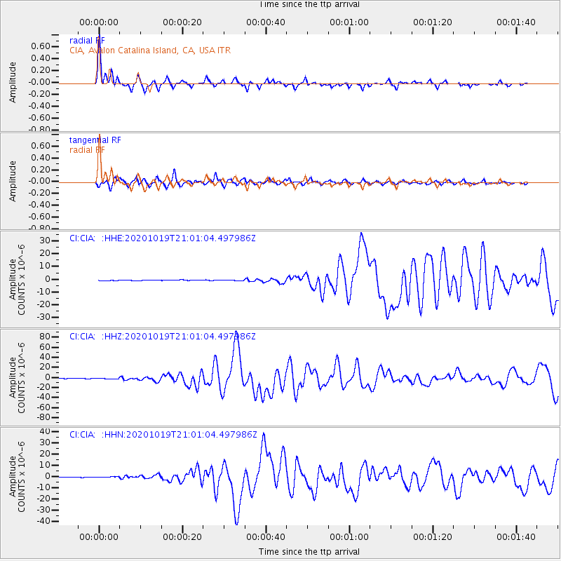
Signal To Noise
| Channel | StoN | STA | LTA |
| CI:CIA: :HHZ:20201019T21:01:04.497986Z | 2.656671 | 6.556341E-7 | 2.4678783E-7 |
| CI:CIA: :HHN:20201019T21:01:04.497986Z | 1.4880716 | 3.8887174E-7 | 2.6132597E-7 |
| CI:CIA: :HHE:20201019T21:01:04.497986Z | 1.2544686 | 2.6859118E-7 | 2.1410754E-7 |
| Arrivals |
| Ps | 9.6 SECOND |
| PpPs | 26 SECOND |
| PsPs/PpSs | 36 SECOND |


