You are here: Home > Network List > CI - Caltech Regional Seismic Network Stations List
> Station SHO Shoshone, CA, USA > Earthquake Result Viewer
SHO Shoshone, CA, USA - Earthquake Result Viewer
| Earthquake location: |
South Of Alaska |
| Earthquake latitude/longitude: |
54.7/-159.6 |
| Earthquake time(UTC): |
2020/10/19 (293) 20:54:40 GMT |
| Earthquake Depth: |
41 km |
| Earthquake Magnitude: |
7.4 Mi |
| Earthquake Catalog/Contributor: |
NEIC PDE/at |
|
| Network: |
CI Caltech Regional Seismic Network |
| Station: |
SHO Shoshone, CA, USA |
| Lat/Lon: |
35.90 N/116.28 W |
| Elevation: |
451 m |
|
| Distance: |
35.1 deg |
| Az: |
104.255 deg |
| Baz: |
316.093 deg |
| Ray Param: |
0.077321105 |
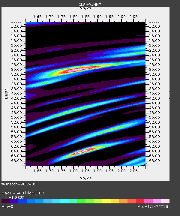
| Estimated Moho Depth: |
64.0 km |
| Estimated Crust Vp/Vs: |
1.83 |
| Assumed Crust Vp: |
6.276 km/s |
| Estimated Crust Vs: |
3.425 km/s |
| Estimated Crust Poisson's Ratio: |
0.29 |
|
| Radial Match: |
90.7409 % |
| Radial Bump: |
400 |
| Transverse Match: |
86.45818 % |
| Transverse Bump: |
400 |
| SOD ConfigId: |
22732711 |
| Insert Time: |
2020-11-02 20:59:20.096 +0000 |
| GWidth: |
2.5 |
| Max Bumps: |
400 |
| Tol: |
0.001 |
|

Signal To Noise
| Channel | StoN | STA | LTA |
| CI:SHO: :HHZ:20201019T21:00:58.928009Z | 4.422413 | 1.0126997E-6 | 2.2899256E-7 |
| CI:SHO: :HHN:20201019T21:00:58.928009Z | 1.3735257 | 4.9951075E-7 | 3.6367044E-7 |
| CI:SHO: :HHE:20201019T21:00:58.928009Z | 1.4051325 | 4.339579E-7 | 3.088377E-7 |
| Arrivals |
| Ps | 9.1 SECOND |
| PpPs | 27 SECOND |
| PsPs/PpSs | 36 SECOND |


