You are here: Home > Network List > CN - Canadian National Seismograph Network Stations List
> Station KAPO KAPUSKASING, ON > Earthquake Result Viewer
KAPO KAPUSKASING, ON - Earthquake Result Viewer
| Earthquake location: |
South Of Alaska |
| Earthquake latitude/longitude: |
54.7/-159.6 |
| Earthquake time(UTC): |
2020/10/19 (293) 20:54:40 GMT |
| Earthquake Depth: |
41 km |
| Earthquake Magnitude: |
7.4 Mi |
| Earthquake Catalog/Contributor: |
NEIC PDE/at |
|
| Network: |
CN Canadian National Seismograph Network |
| Station: |
KAPO KAPUSKASING, ON |
| Lat/Lon: |
49.45 N/82.51 W |
| Elevation: |
210 m |
|
| Distance: |
45.5 deg |
| Az: |
63.183 deg |
| Baz: |
307.399 deg |
| Ray Param: |
0.07116559 |
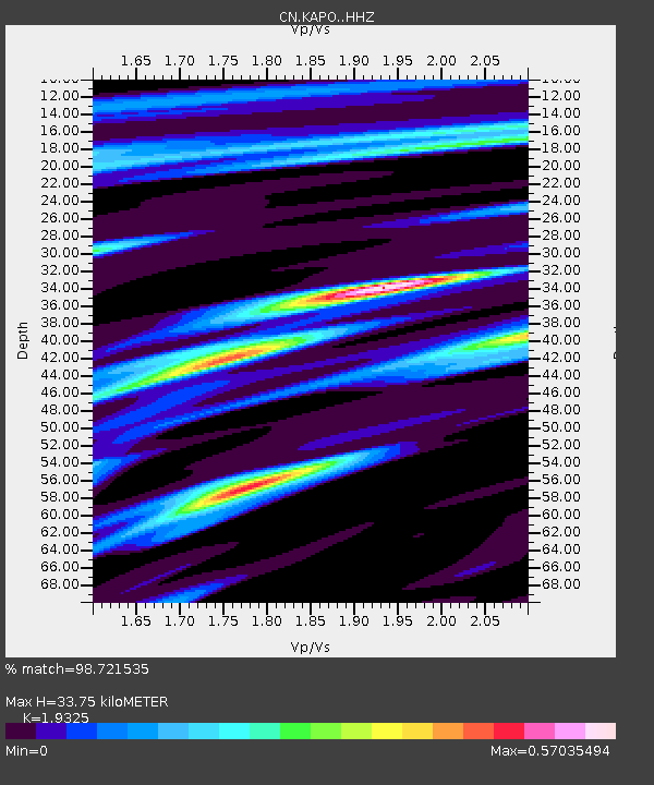
| Estimated Moho Depth: |
33.75 km |
| Estimated Crust Vp/Vs: |
1.93 |
| Assumed Crust Vp: |
6.467 km/s |
| Estimated Crust Vs: |
3.346 km/s |
| Estimated Crust Poisson's Ratio: |
0.32 |
|
| Radial Match: |
98.721535 % |
| Radial Bump: |
231 |
| Transverse Match: |
92.251396 % |
| Transverse Bump: |
400 |
| SOD ConfigId: |
22732711 |
| Insert Time: |
2020-11-02 21:00:29.838 +0000 |
| GWidth: |
2.5 |
| Max Bumps: |
400 |
| Tol: |
0.001 |
|

Signal To Noise
| Channel | StoN | STA | LTA |
| CN:KAPO: :HHZ:20201019T21:02:24.579987Z | 8.52914 | 3.3440574E-6 | 3.9207438E-7 |
| CN:KAPO: :HHN:20201019T21:02:24.579987Z | 2.1548922 | 4.6266658E-7 | 2.147052E-7 |
| CN:KAPO: :HHE:20201019T21:02:24.579987Z | 10.974429 | 1.7219752E-6 | 1.5690794E-7 |
| Arrivals |
| Ps | 5.2 SECOND |
| PpPs | 14 SECOND |
| PsPs/PpSs | 20 SECOND |


