You are here: Home > Network List > CN - Canadian National Seismograph Network Stations List
> Station KILO Kirkland Lake, ON, CA > Earthquake Result Viewer
KILO Kirkland Lake, ON, CA - Earthquake Result Viewer
| Earthquake location: |
South Of Alaska |
| Earthquake latitude/longitude: |
54.7/-159.6 |
| Earthquake time(UTC): |
2020/10/19 (293) 20:54:40 GMT |
| Earthquake Depth: |
41 km |
| Earthquake Magnitude: |
7.4 Mi |
| Earthquake Catalog/Contributor: |
NEIC PDE/at |
|
| Network: |
CN Canadian National Seismograph Network |
| Station: |
KILO Kirkland Lake, ON, CA |
| Lat/Lon: |
48.50 N/79.72 W |
| Elevation: |
314 m |
|
| Distance: |
47.5 deg |
| Az: |
62.649 deg |
| Baz: |
309.126 deg |
| Ray Param: |
0.06987345 |
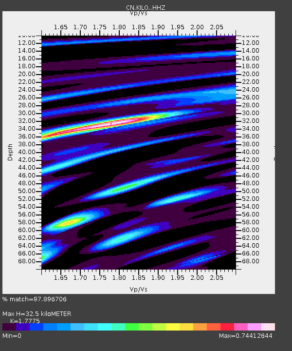
| Estimated Moho Depth: |
32.5 km |
| Estimated Crust Vp/Vs: |
1.78 |
| Assumed Crust Vp: |
6.61 km/s |
| Estimated Crust Vs: |
3.719 km/s |
| Estimated Crust Poisson's Ratio: |
0.27 |
|
| Radial Match: |
97.896706 % |
| Radial Bump: |
290 |
| Transverse Match: |
91.942085 % |
| Transverse Bump: |
400 |
| SOD ConfigId: |
22732711 |
| Insert Time: |
2020-11-02 21:00:32.780 +0000 |
| GWidth: |
2.5 |
| Max Bumps: |
400 |
| Tol: |
0.001 |
|

Signal To Noise
| Channel | StoN | STA | LTA |
| CN:KILO: :HHZ:20201019T21:02:40.470001Z | 8.806828 | 2.4561002E-6 | 2.7888592E-7 |
| CN:KILO: :HHN:20201019T21:02:40.470001Z | 8.230156 | 1.2748862E-6 | 1.5490426E-7 |
| CN:KILO: :HHE:20201019T21:02:40.470001Z | 7.4936204 | 1.1874685E-6 | 1.5846393E-7 |
| Arrivals |
| Ps | 4.1 SECOND |
| PpPs | 13 SECOND |
| PsPs/PpSs | 17 SECOND |


