You are here: Home > Network List > CO - South Carolina Seismic Network Stations List
> Station SUMMV Summerville Airport, SC, USA > Earthquake Result Viewer
SUMMV Summerville Airport, SC, USA - Earthquake Result Viewer
| Earthquake location: |
South Of Alaska |
| Earthquake latitude/longitude: |
54.7/-159.6 |
| Earthquake time(UTC): |
2020/10/19 (293) 20:54:40 GMT |
| Earthquake Depth: |
41 km |
| Earthquake Magnitude: |
7.4 Mi |
| Earthquake Catalog/Contributor: |
NEIC PDE/at |
|
| Network: |
CO South Carolina Seismic Network |
| Station: |
SUMMV Summerville Airport, SC, USA |
| Lat/Lon: |
33.07 N/80.27 W |
| Elevation: |
17 m |
|
| Distance: |
57.8 deg |
| Az: |
77.102 deg |
| Baz: |
317.594 deg |
| Ray Param: |
0.063153476 |
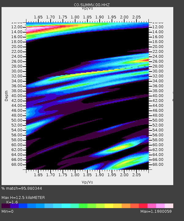
| Estimated Moho Depth: |
12.5 km |
| Estimated Crust Vp/Vs: |
1.60 |
| Assumed Crust Vp: |
6.565 km/s |
| Estimated Crust Vs: |
4.103 km/s |
| Estimated Crust Poisson's Ratio: |
0.18 |
|
| Radial Match: |
95.860344 % |
| Radial Bump: |
305 |
| Transverse Match: |
75.18604 % |
| Transverse Bump: |
388 |
| SOD ConfigId: |
22732711 |
| Insert Time: |
2020-11-02 21:01:19.666 +0000 |
| GWidth: |
2.5 |
| Max Bumps: |
400 |
| Tol: |
0.001 |
|

Signal To Noise
| Channel | StoN | STA | LTA |
| CO:SUMMV:00:HHZ:20201019T21:03:56.77002Z | 4.43848 | 3.0146605E-6 | 6.792101E-7 |
| CO:SUMMV:00:HH1:20201019T21:03:56.77002Z | 0.82103336 | 1.4166135E-6 | 1.725403E-6 |
| CO:SUMMV:00:HH2:20201019T21:03:56.77002Z | 0.6535697 | 1.4227129E-6 | 2.1768344E-6 |
| Arrivals |
| Ps | 1.2 SECOND |
| PpPs | 4.7 SECOND |
| PsPs/PpSs | 5.9 SECOND |


