You are here: Home > Network List > GB - Great Britain Seismograph Network Stations List
> Station CLGH CUSHENDALL, NORTHERN IRELAND > Earthquake Result Viewer
CLGH CUSHENDALL, NORTHERN IRELAND - Earthquake Result Viewer
| Earthquake location: |
South Of Alaska |
| Earthquake latitude/longitude: |
54.7/-159.6 |
| Earthquake time(UTC): |
2020/10/19 (293) 20:54:40 GMT |
| Earthquake Depth: |
41 km |
| Earthquake Magnitude: |
7.4 Mi |
| Earthquake Catalog/Contributor: |
NEIC PDE/at |
|
| Network: |
GB Great Britain Seismograph Network |
| Station: |
CLGH CUSHENDALL, NORTHERN IRELAND |
| Lat/Lon: |
55.08 N/6.11 W |
| Elevation: |
239 m |
|
| Distance: |
68.5 deg |
| Az: |
16.011 deg |
| Baz: |
343.818 deg |
| Ray Param: |
0.056214776 |
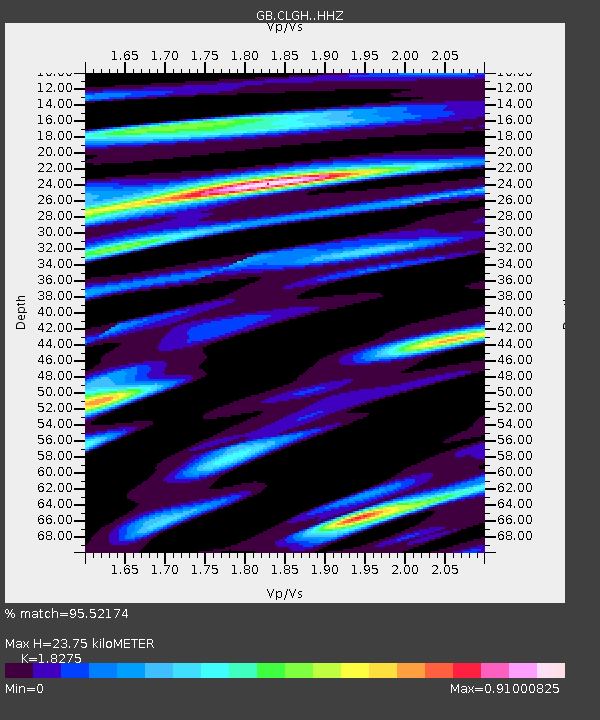
| Estimated Moho Depth: |
23.75 km |
| Estimated Crust Vp/Vs: |
1.83 |
| Assumed Crust Vp: |
6.276 km/s |
| Estimated Crust Vs: |
3.434 km/s |
| Estimated Crust Poisson's Ratio: |
0.29 |
|
| Radial Match: |
95.52174 % |
| Radial Bump: |
400 |
| Transverse Match: |
78.588905 % |
| Transverse Bump: |
400 |
| SOD ConfigId: |
22732711 |
| Insert Time: |
2020-11-02 21:02:51.858 +0000 |
| GWidth: |
2.5 |
| Max Bumps: |
400 |
| Tol: |
0.001 |
|

Signal To Noise
| Channel | StoN | STA | LTA |
| GB:CLGH: :HHZ:20201019T21:05:07.049988Z | 1.4887183 | 1.6755715E-6 | 1.1255128E-6 |
| GB:CLGH: :HHN:20201019T21:05:07.049988Z | 1.247589 | 7.2173555E-7 | 5.785043E-7 |
| GB:CLGH: :HHE:20201019T21:05:07.049988Z | 1.1565772 | 8.0783616E-7 | 6.9847147E-7 |
| Arrivals |
| Ps | 3.2 SECOND |
| PpPs | 10 SECOND |
| PsPs/PpSs | 14 SECOND |


