You are here: Home > Network List > GB - Great Britain Seismograph Network Stations List
> Station HTL HARTLAND, ENGLAND > Earthquake Result Viewer
HTL HARTLAND, ENGLAND - Earthquake Result Viewer
| Earthquake location: |
South Of Alaska |
| Earthquake latitude/longitude: |
54.7/-159.6 |
| Earthquake time(UTC): |
2020/10/19 (293) 20:54:40 GMT |
| Earthquake Depth: |
41 km |
| Earthquake Magnitude: |
7.4 Mi |
| Earthquake Catalog/Contributor: |
NEIC PDE/at |
|
| Network: |
GB Great Britain Seismograph Network |
| Station: |
HTL HARTLAND, ENGLAND |
| Lat/Lon: |
50.99 N/4.48 W |
| Elevation: |
86 m |
|
| Distance: |
72.7 deg |
| Az: |
16.169 deg |
| Baz: |
345.167 deg |
| Ray Param: |
0.053446017 |
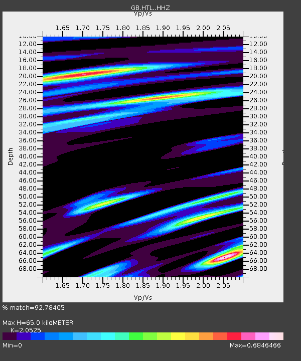
| Estimated Moho Depth: |
65.0 km |
| Estimated Crust Vp/Vs: |
2.05 |
| Assumed Crust Vp: |
6.24 km/s |
| Estimated Crust Vs: |
3.04 km/s |
| Estimated Crust Poisson's Ratio: |
0.34 |
|
| Radial Match: |
92.78405 % |
| Radial Bump: |
368 |
| Transverse Match: |
81.5519 % |
| Transverse Bump: |
400 |
| SOD ConfigId: |
22732711 |
| Insert Time: |
2020-11-02 21:03:10.078 +0000 |
| GWidth: |
2.5 |
| Max Bumps: |
400 |
| Tol: |
0.001 |
|

Signal To Noise
| Channel | StoN | STA | LTA |
| GB:HTL: :HHZ:20201019T21:05:32.619995Z | 1.9637564 | 4.2055316E-7 | 2.141575E-7 |
| GB:HTL: :HHN:20201019T21:05:32.619995Z | 0.6601932 | 1.273583E-7 | 1.9291065E-7 |
| GB:HTL: :HHE:20201019T21:05:32.619995Z | 1.382631 | 2.0631178E-7 | 1.4921682E-7 |
| Arrivals |
| Ps | 11 SECOND |
| PpPs | 31 SECOND |
| PsPs/PpSs | 42 SECOND |


