You are here: Home > Network List > GB - Great Britain Seismograph Network Stations List
> Station KESW KESWICK, ENGLAND > Earthquake Result Viewer
KESW KESWICK, ENGLAND - Earthquake Result Viewer
| Earthquake location: |
South Of Alaska |
| Earthquake latitude/longitude: |
54.7/-159.6 |
| Earthquake time(UTC): |
2020/10/19 (293) 20:54:40 GMT |
| Earthquake Depth: |
41 km |
| Earthquake Magnitude: |
7.4 Mi |
| Earthquake Catalog/Contributor: |
NEIC PDE/at |
|
| Network: |
GB Great Britain Seismograph Network |
| Station: |
KESW KESWICK, ENGLAND |
| Lat/Lon: |
54.59 N/3.10 W |
| Elevation: |
282 m |
|
| Distance: |
69.4 deg |
| Az: |
14.352 deg |
| Baz: |
345.675 deg |
| Ray Param: |
0.055597734 |
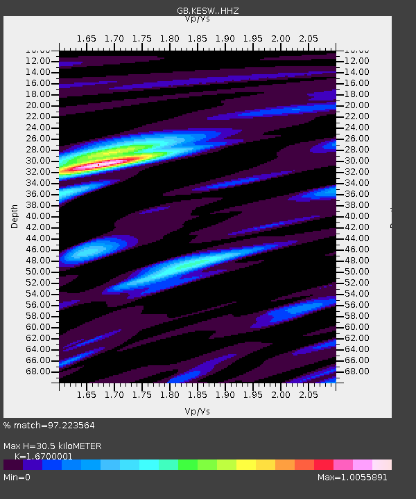
| Estimated Moho Depth: |
30.5 km |
| Estimated Crust Vp/Vs: |
1.67 |
| Assumed Crust Vp: |
6.276 km/s |
| Estimated Crust Vs: |
3.758 km/s |
| Estimated Crust Poisson's Ratio: |
0.22 |
|
| Radial Match: |
97.223564 % |
| Radial Bump: |
400 |
| Transverse Match: |
80.15216 % |
| Transverse Bump: |
400 |
| SOD ConfigId: |
22732711 |
| Insert Time: |
2020-11-02 21:03:15.971 +0000 |
| GWidth: |
2.5 |
| Max Bumps: |
400 |
| Tol: |
0.001 |
|

Signal To Noise
| Channel | StoN | STA | LTA |
| GB:KESW: :HHZ:20201019T21:05:12.849976Z | 3.1487288 | 1.6495542E-6 | 5.238794E-7 |
| GB:KESW: :HHN:20201019T21:05:12.849976Z | 1.3493905 | 9.2451063E-7 | 6.851321E-7 |
| GB:KESW: :HHE:20201019T21:05:12.849976Z | 1.0920287 | 5.2448326E-7 | 4.802834E-7 |
| Arrivals |
| Ps | 3.4 SECOND |
| PpPs | 12 SECOND |
| PsPs/PpSs | 16 SECOND |


