You are here: Home > Network List > GE - GEOFON Stations List
> Station EIL GEOFON Station Eilat, Israel > Earthquake Result Viewer
EIL GEOFON Station Eilat, Israel - Earthquake Result Viewer
| Earthquake location: |
South Of Alaska |
| Earthquake latitude/longitude: |
54.7/-159.6 |
| Earthquake time(UTC): |
2020/10/19 (293) 20:54:40 GMT |
| Earthquake Depth: |
41 km |
| Earthquake Magnitude: |
7.4 Mi |
| Earthquake Catalog/Contributor: |
NEIC PDE/at |
|
| Network: |
GE GEOFON |
| Station: |
EIL GEOFON Station Eilat, Israel |
| Lat/Lon: |
29.67 N/34.95 E |
| Elevation: |
210 m |
|
| Distance: |
95.1 deg |
| Az: |
347.312 deg |
| Baz: |
8.431 deg |
| Ray Param: |
0.040866803 |
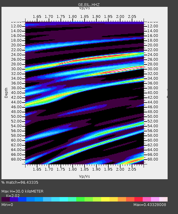
| Estimated Moho Depth: |
30.0 km |
| Estimated Crust Vp/Vs: |
2.02 |
| Assumed Crust Vp: |
6.472 km/s |
| Estimated Crust Vs: |
3.204 km/s |
| Estimated Crust Poisson's Ratio: |
0.34 |
|
| Radial Match: |
96.43335 % |
| Radial Bump: |
400 |
| Transverse Match: |
87.967995 % |
| Transverse Bump: |
400 |
| SOD ConfigId: |
22732711 |
| Insert Time: |
2020-11-02 21:03:32.065 +0000 |
| GWidth: |
2.5 |
| Max Bumps: |
400 |
| Tol: |
0.001 |
|

Signal To Noise
| Channel | StoN | STA | LTA |
| GE:EIL: :HHZ:20201019T21:07:27.250Z | 8.8013525 | 5.731833E-7 | 6.512445E-8 |
| GE:EIL: :HHN:20201019T21:07:27.250Z | 3.9471033 | 1.6022149E-7 | 4.059217E-8 |
| GE:EIL: :HHE:20201019T21:07:27.250Z | 1.4292157 | 6.345272E-8 | 4.439688E-8 |
| Arrivals |
| Ps | 4.8 SECOND |
| PpPs | 14 SECOND |
| PsPs/PpSs | 19 SECOND |


