You are here: Home > Network List > GL - Volcanologic Seismologic Observatory Network of Guadeloupe -OVSG Stations List
> Station MML Mamelle > Earthquake Result Viewer
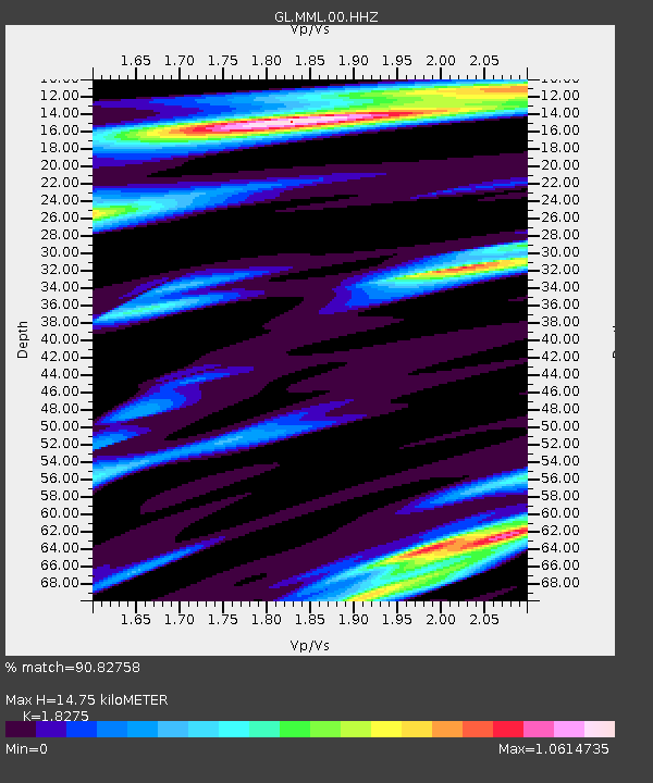
MML Mamelle - Earthquake Result Viewer
| Earthquake location: |
South Of Alaska |
| Earthquake latitude/longitude: |
54.7/-159.6 |
| Earthquake time(UTC): |
2020/10/19 (293) 20:54:40 GMT |
| Earthquake Depth: |
41 km |
| Earthquake Magnitude: |
7.4 Mi |
| Earthquake Catalog/Contributor: |
NEIC PDE/at |
|
| Network: |
GL Volcanologic Seismologic Observatory Network of Guadeloupe -OVSG |
| Station: |
MML Mamelle |
| Lat/Lon: |
16.04 N/61.67 W |
| Elevation: |
1197 m |
|
| Distance: |
81.6 deg |
| Az: |
74.301 deg |
| Baz: |
324.434 deg |
| Ray Param: |
0.0474272 |
| Estimated Moho Depth: |
14.75 km |
| Estimated Crust Vp/Vs: |
1.83 |
| Assumed Crust Vp: |
6.048 km/s |
| Estimated Crust Vs: |
3.309 km/s |
| Estimated Crust Poisson's Ratio: |
0.29 |
|
| Radial Match: |
90.82758 % |
| Radial Bump: |
310 |
| Transverse Match: |
88.848946 % |
| Transverse Bump: |
400 |
| SOD ConfigId: |
22732711 |
| Insert Time: |
2020-11-02 21:03:56.962 +0000 |
| GWidth: |
2.5 |
| Max Bumps: |
400 |
| Tol: |
0.001 |
|

Signal To Noise
| Channel | StoN | STA | LTA |
| GL:MML:00:HHZ:20201019T21:06:22.409973Z | 16.708433 | 1.8415725E-6 | 1.10218146E-7 |
| GL:MML:00:HHN:20201019T21:06:22.409973Z | 3.7766926 | 7.7889587E-7 | 2.0623756E-7 |
| GL:MML:00:HHE:20201019T21:06:22.409973Z | 1.9959992 | 4.8867184E-7 | 2.4482566E-7 |
| Arrivals |
| Ps | 2.1 SECOND |
| PpPs | 6.7 SECOND |
| PsPs/PpSs | 8.8 SECOND |


