You are here: Home > Network List > GL - Volcanologic Seismologic Observatory Network of Guadeloupe -OVSG Stations List
> Station MOG Mont d'Or > Earthquake Result Viewer
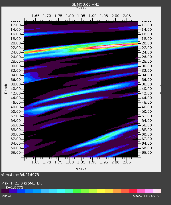
MOG Mont d'Or - Earthquake Result Viewer
| Earthquake location: |
South Of Alaska |
| Earthquake latitude/longitude: |
54.7/-159.6 |
| Earthquake time(UTC): |
2020/10/19 (293) 20:54:40 GMT |
| Earthquake Depth: |
41 km |
| Earthquake Magnitude: |
7.4 Mi |
| Earthquake Catalog/Contributor: |
NEIC PDE/at |
|
| Network: |
GL Volcanologic Seismologic Observatory Network of Guadeloupe -OVSG |
| Station: |
MOG Mont d'Or |
| Lat/Lon: |
16.06 N/61.72 W |
| Elevation: |
613 m |
|
| Distance: |
81.5 deg |
| Az: |
74.33 deg |
| Baz: |
324.425 deg |
| Ray Param: |
0.047453362 |
| Estimated Moho Depth: |
21.0 km |
| Estimated Crust Vp/Vs: |
1.98 |
| Assumed Crust Vp: |
6.048 km/s |
| Estimated Crust Vs: |
3.058 km/s |
| Estimated Crust Poisson's Ratio: |
0.33 |
|
| Radial Match: |
86.016075 % |
| Radial Bump: |
400 |
| Transverse Match: |
87.1854 % |
| Transverse Bump: |
400 |
| SOD ConfigId: |
22732711 |
| Insert Time: |
2020-11-02 21:03:59.604 +0000 |
| GWidth: |
2.5 |
| Max Bumps: |
400 |
| Tol: |
0.001 |
|

Signal To Noise
| Channel | StoN | STA | LTA |
| GL:MOG:00:HHZ:20201019T21:06:22.210022Z | 8.4294195 | 2.1181754E-7 | 2.5128365E-8 |
| GL:MOG:00:HHN:20201019T21:06:22.210022Z | 1.3412572 | 1.639215E-6 | 1.2221482E-6 |
| GL:MOG:00:HHE:20201019T21:06:22.210022Z | 2.591026 | 2.8240495E-6 | 1.0899348E-6 |
| Arrivals |
| Ps | 3.5 SECOND |
| PpPs | 10 SECOND |
| PsPs/PpSs | 14 SECOND |


