You are here: Home > Network List > GS - US Geological Survey Networks Stations List
> Station OK038 West end E0370 Rd, Waynoka, OK, USA > Earthquake Result Viewer
OK038 West end E0370 Rd, Waynoka, OK, USA - Earthquake Result Viewer
| Earthquake location: |
South Of Alaska |
| Earthquake latitude/longitude: |
54.7/-159.6 |
| Earthquake time(UTC): |
2020/10/19 (293) 20:54:40 GMT |
| Earthquake Depth: |
41 km |
| Earthquake Magnitude: |
7.4 Mi |
| Earthquake Catalog/Contributor: |
NEIC PDE/at |
|
| Network: |
GS US Geological Survey Networks |
| Station: |
OK038 West end E0370 Rd, Waynoka, OK, USA |
| Lat/Lon: |
36.48 N/98.74 W |
| Elevation: |
443 m |
|
| Distance: |
44.8 deg |
| Az: |
88.008 deg |
| Baz: |
313.917 deg |
| Ray Param: |
0.0716113 |
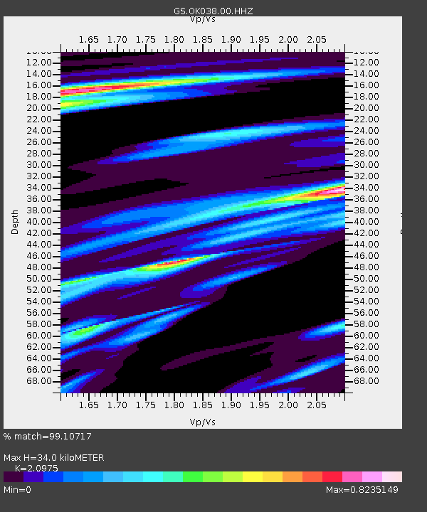
| Estimated Moho Depth: |
34.0 km |
| Estimated Crust Vp/Vs: |
2.10 |
| Assumed Crust Vp: |
6.426 km/s |
| Estimated Crust Vs: |
3.064 km/s |
| Estimated Crust Poisson's Ratio: |
0.35 |
|
| Radial Match: |
99.10717 % |
| Radial Bump: |
300 |
| Transverse Match: |
93.317665 % |
| Transverse Bump: |
400 |
| SOD ConfigId: |
22732711 |
| Insert Time: |
2020-11-02 21:04:38.470 +0000 |
| GWidth: |
2.5 |
| Max Bumps: |
400 |
| Tol: |
0.001 |
|

Signal To Noise
| Channel | StoN | STA | LTA |
| GS:OK038:00:HHZ:20201019T21:02:19.18399Z | 14.767156 | 2.0117798E-6 | 1.362334E-7 |
| GS:OK038:00:HH1:20201019T21:02:19.18399Z | 2.8557847 | 6.8283964E-7 | 2.3910755E-7 |
| GS:OK038:00:HH2:20201019T21:02:19.18399Z | 3.3235304 | 7.823935E-7 | 2.3541038E-7 |
| Arrivals |
| Ps | 6.1 SECOND |
| PpPs | 16 SECOND |
| PsPs/PpSs | 22 SECOND |


