You are here: Home > Network List > GS - US Geological Survey Networks Stations List
> Station PR03 PR03, Alturas Sabaneras > Earthquake Result Viewer
PR03 PR03, Alturas Sabaneras - Earthquake Result Viewer
| Earthquake location: |
South Of Alaska |
| Earthquake latitude/longitude: |
54.7/-159.6 |
| Earthquake time(UTC): |
2020/10/19 (293) 20:54:40 GMT |
| Earthquake Depth: |
41 km |
| Earthquake Magnitude: |
7.4 Mi |
| Earthquake Catalog/Contributor: |
NEIC PDE/at |
|
| Network: |
GS US Geological Survey Networks |
| Station: |
PR03 PR03, Alturas Sabaneras |
| Lat/Lon: |
18.07 N/66.94 W |
| Elevation: |
113 m |
|
| Distance: |
77.0 deg |
| Az: |
77.243 deg |
| Baz: |
323.444 deg |
| Ray Param: |
0.050559968 |
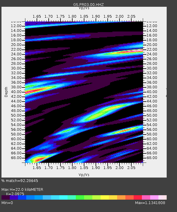
| Estimated Moho Depth: |
22.0 km |
| Estimated Crust Vp/Vs: |
2.10 |
| Assumed Crust Vp: |
5.14 km/s |
| Estimated Crust Vs: |
2.451 km/s |
| Estimated Crust Poisson's Ratio: |
0.35 |
|
| Radial Match: |
92.28645 % |
| Radial Bump: |
400 |
| Transverse Match: |
91.53033 % |
| Transverse Bump: |
400 |
| SOD ConfigId: |
22732711 |
| Insert Time: |
2020-11-02 21:04:47.261 +0000 |
| GWidth: |
2.5 |
| Max Bumps: |
400 |
| Tol: |
0.001 |
|

Signal To Noise
| Channel | StoN | STA | LTA |
| GS:PR03:00:HHZ:20201019T21:05:57.460022Z | 7.5284247 | 1.1180647E-6 | 1.4851243E-7 |
| GS:PR03:00:HH1:20201019T21:05:57.460022Z | 1.250438 | 3.981507E-7 | 3.18409E-7 |
| GS:PR03:00:HH2:20201019T21:05:57.460022Z | 1.9825408 | 4.708664E-7 | 2.3750653E-7 |
| Arrivals |
| Ps | 4.8 SECOND |
| PpPs | 13 SECOND |
| PsPs/PpSs | 18 SECOND |


