You are here: Home > Network List > GS - US Geological Survey Networks Stations List
> Station PR04 PR04, Ponce > Earthquake Result Viewer
PR04 PR04, Ponce - Earthquake Result Viewer
| Earthquake location: |
South Of Alaska |
| Earthquake latitude/longitude: |
54.7/-159.6 |
| Earthquake time(UTC): |
2020/10/19 (293) 20:54:40 GMT |
| Earthquake Depth: |
41 km |
| Earthquake Magnitude: |
7.4 Mi |
| Earthquake Catalog/Contributor: |
NEIC PDE/at |
|
| Network: |
GS US Geological Survey Networks |
| Station: |
PR04 PR04, Ponce |
| Lat/Lon: |
17.98 N/66.67 W |
| Elevation: |
57 m |
|
| Distance: |
77.2 deg |
| Az: |
77.087 deg |
| Baz: |
323.492 deg |
| Ray Param: |
0.050410684 |
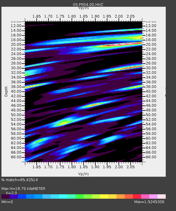
| Estimated Moho Depth: |
19.75 km |
| Estimated Crust Vp/Vs: |
2.00 |
| Assumed Crust Vp: |
4.082 km/s |
| Estimated Crust Vs: |
2.041 km/s |
| Estimated Crust Poisson's Ratio: |
0.33 |
|
| Radial Match: |
95.42514 % |
| Radial Bump: |
400 |
| Transverse Match: |
93.391136 % |
| Transverse Bump: |
400 |
| SOD ConfigId: |
22732711 |
| Insert Time: |
2020-11-02 21:04:48.758 +0000 |
| GWidth: |
2.5 |
| Max Bumps: |
400 |
| Tol: |
0.001 |
|

Signal To Noise
| Channel | StoN | STA | LTA |
| GS:PR04:00:HHZ:20201019T21:05:58.708984Z | 16.236254 | 2.3065159E-6 | 1.420596E-7 |
| GS:PR04:00:HH1:20201019T21:05:58.708984Z | 1.7709261 | 6.9473117E-7 | 3.9229823E-7 |
| GS:PR04:00:HH2:20201019T21:05:58.708984Z | 0.82712275 | 4.812815E-7 | 5.818743E-7 |
| Arrivals |
| Ps | 4.9 SECOND |
| PpPs | 14 SECOND |
| PsPs/PpSs | 19 SECOND |


