You are here: Home > Network List > IU - Global Seismograph Network (GSN - IRIS/USGS) Stations List
> Station TATO Taipei, Taiwan > Earthquake Result Viewer
TATO Taipei, Taiwan - Earthquake Result Viewer
| Earthquake location: |
South Of Alaska |
| Earthquake latitude/longitude: |
54.7/-159.6 |
| Earthquake time(UTC): |
2020/10/19 (293) 20:54:40 GMT |
| Earthquake Depth: |
41 km |
| Earthquake Magnitude: |
7.4 Mi |
| Earthquake Catalog/Contributor: |
NEIC PDE/at |
|
| Network: |
IU Global Seismograph Network (GSN - IRIS/USGS) |
| Station: |
TATO Taipei, Taiwan |
| Lat/Lon: |
24.97 N/121.50 E |
| Elevation: |
160 m |
|
| Distance: |
63.7 deg |
| Az: |
276.511 deg |
| Baz: |
39.492 deg |
| Ray Param: |
0.05934187 |
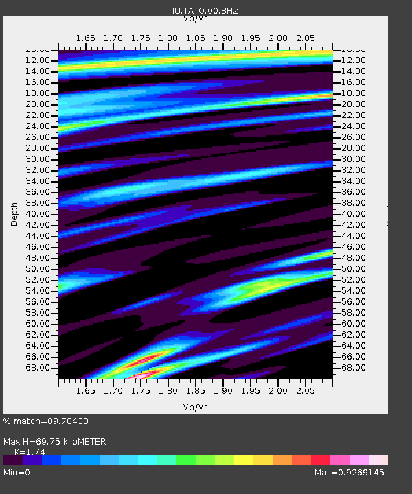
| Estimated Moho Depth: |
69.75 km |
| Estimated Crust Vp/Vs: |
1.74 |
| Assumed Crust Vp: |
6.289 km/s |
| Estimated Crust Vs: |
3.614 km/s |
| Estimated Crust Poisson's Ratio: |
0.25 |
|
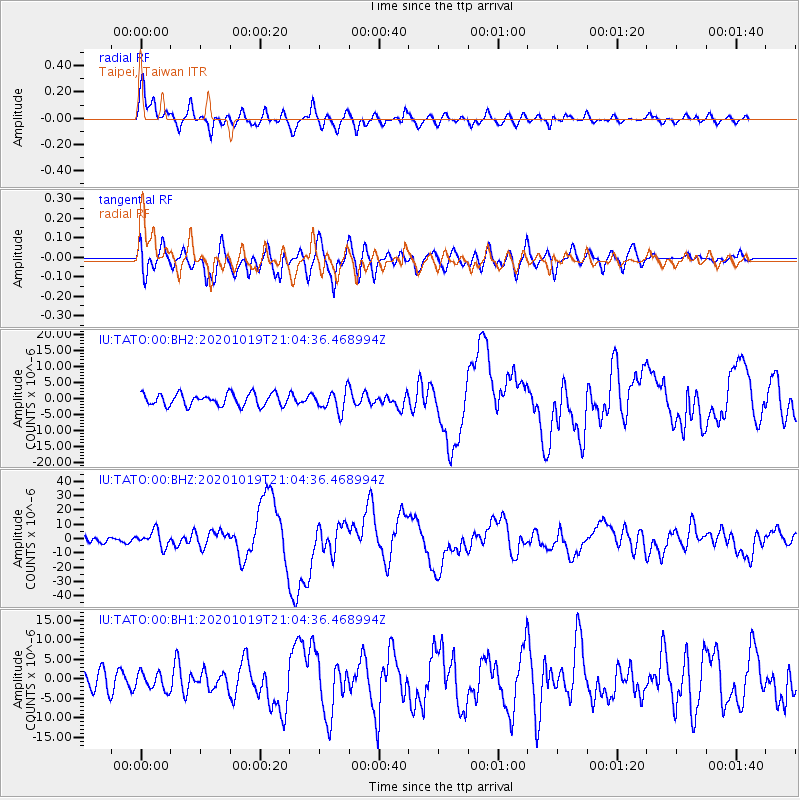
| Radial Match: |
89.78438 % |
| Radial Bump: |
400 |
| Transverse Match: |
78.3309 % |
| Transverse Bump: |
400 |
| SOD ConfigId: |
22732711 |
| Insert Time: |
2020-11-02 21:06:31.644 +0000 |
| GWidth: |
2.5 |
| Max Bumps: |
400 |
| Tol: |
0.001 |
|
Signal To Noise
| Channel | StoN | STA | LTA |
| IU:TATO:00:BHZ:20201019T21:04:36.468994Z | 1.9281946 | 5.606236E-6 | 2.9075052E-6 |
| IU:TATO:00:BH1:20201019T21:04:36.468994Z | 1.1338756 | 2.2582146E-6 | 1.9915894E-6 |
| IU:TATO:00:BH2:20201019T21:04:36.468994Z | 1.6898961 | 3.2279122E-6 | 1.9101246E-6 |
| Arrivals |
| Ps | 8.6 SECOND |
| PpPs | 29 SECOND |
| PsPs/PpSs | 38 SECOND |


