You are here: Home > Network List > MM - Myanmar National Seismic Network Stations List
> Station YGN Yangon, Yangon, Myanmar > Earthquake Result Viewer
YGN Yangon, Yangon, Myanmar - Earthquake Result Viewer
| Earthquake location: |
South Of Alaska |
| Earthquake latitude/longitude: |
54.7/-159.6 |
| Earthquake time(UTC): |
2020/10/19 (293) 20:54:40 GMT |
| Earthquake Depth: |
41 km |
| Earthquake Magnitude: |
7.4 Mi |
| Earthquake Catalog/Contributor: |
NEIC PDE/at |
|
| Network: |
MM Myanmar National Seismic Network |
| Station: |
YGN Yangon, Yangon, Myanmar |
| Lat/Lon: |
16.86 N/96.15 E |
| Elevation: |
20 m |
|
| Distance: |
84.4 deg |
| Az: |
291.158 deg |
| Baz: |
34.459 deg |
| Ray Param: |
0.045462754 |
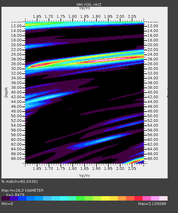
| Estimated Moho Depth: |
26.0 km |
| Estimated Crust Vp/Vs: |
1.95 |
| Assumed Crust Vp: |
6.287 km/s |
| Estimated Crust Vs: |
3.228 km/s |
| Estimated Crust Poisson's Ratio: |
0.32 |
|
| Radial Match: |
90.04351 % |
| Radial Bump: |
400 |
| Transverse Match: |
82.697495 % |
| Transverse Bump: |
400 |
| SOD ConfigId: |
22732711 |
| Insert Time: |
2020-11-02 21:08:56.122 +0000 |
| GWidth: |
2.5 |
| Max Bumps: |
400 |
| Tol: |
0.001 |
|

Signal To Noise
| Channel | StoN | STA | LTA |
| MM:YGN: :HHZ:20201019T21:06:36.848022Z | 2.2393148 | 3.6831268E-6 | 1.6447561E-6 |
| MM:YGN: :HHN:20201019T21:06:36.848022Z | 1.0638779 | 2.6518921E-6 | 2.4926658E-6 |
| MM:YGN: :HHE:20201019T21:06:36.848022Z | 1.1795285 | 4.093069E-6 | 3.4700893E-6 |
| Arrivals |
| Ps | 4.0 SECOND |
| PpPs | 12 SECOND |
| PsPs/PpSs | 16 SECOND |


