You are here: Home > Network List > N4 - Central and EAstern US Network Stations List
> Station 352A Blakely, GA, USA > Earthquake Result Viewer
352A Blakely, GA, USA - Earthquake Result Viewer
| Earthquake location: |
South Of Alaska |
| Earthquake latitude/longitude: |
54.7/-159.6 |
| Earthquake time(UTC): |
2020/10/19 (293) 20:54:40 GMT |
| Earthquake Depth: |
41 km |
| Earthquake Magnitude: |
7.4 Mi |
| Earthquake Catalog/Contributor: |
NEIC PDE/at |
|
| Network: |
N4 Central and EAstern US Network |
| Station: |
352A Blakely, GA, USA |
| Lat/Lon: |
31.48 N/84.93 W |
| Elevation: |
101 m |
|
| Distance: |
56.4 deg |
| Az: |
81.84 deg |
| Baz: |
317.696 deg |
| Ray Param: |
0.06411536 |
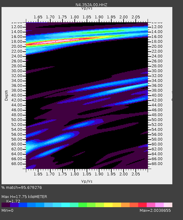
| Estimated Moho Depth: |
17.75 km |
| Estimated Crust Vp/Vs: |
1.72 |
| Assumed Crust Vp: |
6.347 km/s |
| Estimated Crust Vs: |
3.69 km/s |
| Estimated Crust Poisson's Ratio: |
0.24 |
|
| Radial Match: |
95.679276 % |
| Radial Bump: |
262 |
| Transverse Match: |
85.72546 % |
| Transverse Bump: |
400 |
| SOD ConfigId: |
22732711 |
| Insert Time: |
2020-11-02 21:09:33.707 +0000 |
| GWidth: |
2.5 |
| Max Bumps: |
400 |
| Tol: |
0.001 |
|

Signal To Noise
| Channel | StoN | STA | LTA |
| N4:352A:00:HHZ:20201019T21:03:46.27002Z | 3.2475538 | 2.0345087E-6 | 6.264742E-7 |
| N4:352A:00:HH1:20201019T21:03:46.27002Z | 1.7704861 | 9.23356E-7 | 5.2152683E-7 |
| N4:352A:00:HH2:20201019T21:03:46.27002Z | 1.7011077 | 8.547592E-7 | 5.024721E-7 |
| Arrivals |
| Ps | 2.1 SECOND |
| PpPs | 7.2 SECOND |
| PsPs/PpSs | 9.3 SECOND |


