You are here: Home > Network List > N4 - Central and EAstern US Network Stations List
> Station H62A Milan, NH, USA > Earthquake Result Viewer
H62A Milan, NH, USA - Earthquake Result Viewer
| Earthquake location: |
South Of Alaska |
| Earthquake latitude/longitude: |
54.7/-159.6 |
| Earthquake time(UTC): |
2020/10/19 (293) 20:54:40 GMT |
| Earthquake Depth: |
41 km |
| Earthquake Magnitude: |
7.4 Mi |
| Earthquake Catalog/Contributor: |
NEIC PDE/at |
|
| Network: |
N4 Central and EAstern US Network |
| Station: |
H62A Milan, NH, USA |
| Lat/Lon: |
44.57 N/71.16 W |
| Elevation: |
381 m |
|
| Distance: |
54.5 deg |
| Az: |
61.332 deg |
| Baz: |
314.503 deg |
| Ray Param: |
0.06531961 |
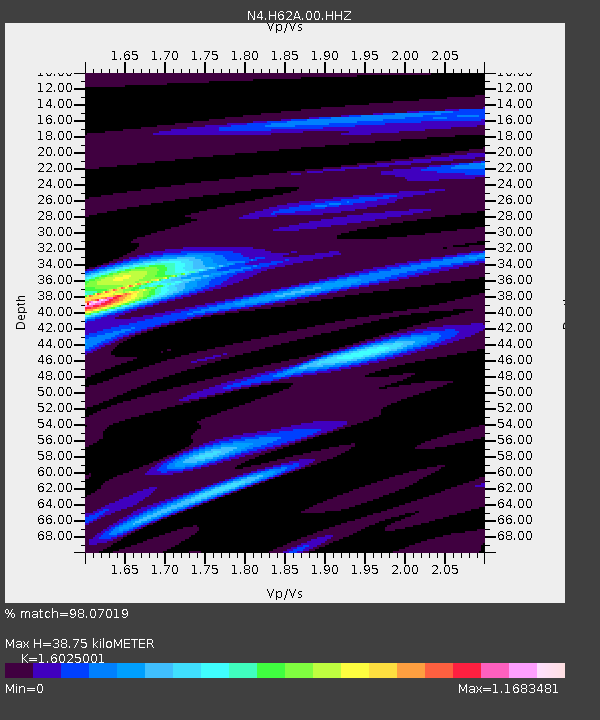
| Estimated Moho Depth: |
38.75 km |
| Estimated Crust Vp/Vs: |
1.60 |
| Assumed Crust Vp: |
6.419 km/s |
| Estimated Crust Vs: |
4.006 km/s |
| Estimated Crust Poisson's Ratio: |
0.18 |
|
| Radial Match: |
98.07019 % |
| Radial Bump: |
291 |
| Transverse Match: |
92.22842 % |
| Transverse Bump: |
400 |
| SOD ConfigId: |
22732711 |
| Insert Time: |
2020-11-02 21:10:00.226 +0000 |
| GWidth: |
2.5 |
| Max Bumps: |
400 |
| Tol: |
0.001 |
|

Signal To Noise
| Channel | StoN | STA | LTA |
| N4:H62A:00:HHZ:20201019T21:03:33.078979Z | 12.203822 | 2.737305E-6 | 2.2429899E-7 |
| N4:H62A:00:HH1:20201019T21:03:33.078979Z | 7.595112 | 1.3957941E-6 | 1.8377533E-7 |
| N4:H62A:00:HH2:20201019T21:03:33.078979Z | 6.151501 | 1.1594412E-6 | 1.8848101E-7 |
| Arrivals |
| Ps | 3.9 SECOND |
| PpPs | 15 SECOND |
| PsPs/PpSs | 19 SECOND |


